Are you eager to witness the stunning Pictured Rocks National Lakeshore without setting sail? At rockscapes.net, we’re here to guide you through the best land-based viewpoints and trails for experiencing this natural wonder, focusing on accessible and breathtaking landscapes. Discover the beauty of Pictured Rocks from a new perspective, exploring the unique rock formations and lakeshore vistas.
1. What Are Pictured Rocks and Where Are They Located?
Pictured Rocks are sandstone cliffs along the shore of Lake Superior in Michigan’s Upper Peninsula, renowned for their vibrant mineral stains. These formations, part of the Pictured Rocks National Lakeshore, stretch over 40 miles and are accessible by land, offering stunning views for hikers and nature enthusiasts. The park is located in Alger County, Michigan.
1.1 What Makes Pictured Rocks Unique?
The uniqueness of Pictured Rocks lies in its geological formations and the colorful patterns created by mineral-rich groundwater seeping through the sandstone. Iron, manganese, copper, and other minerals create a stunning palette of colors, making each rock formation a unique work of art. The combination of these vibrant cliffs with the clear blue waters of Lake Superior creates a breathtaking landscape.
1.2 Why Should You Visit Pictured Rocks?
Visiting Pictured Rocks offers a chance to witness nature’s artistry, explore diverse hiking trails, and enjoy the serene beauty of Lake Superior. Whether you’re a seasoned hiker, a nature photographer, or simply someone seeking a peaceful escape, Pictured Rocks provides an unforgettable experience. The area also offers opportunities for camping, kayaking, and wildlife viewing, ensuring there’s something for everyone to enjoy.
2. Planning Your Trip to See Pictured Rocks from Land
To make the most of your visit, careful planning is essential. Consider the best time to visit, the necessary permits, and the best routes to access the key viewpoints.
2.1 What Is the Best Time to Visit Pictured Rocks?
The best time to visit Pictured Rocks is during the late spring, summer, or early fall for pleasant weather and optimal viewing conditions. Summer offers the warmest temperatures, perfect for hiking and swimming, while fall brings vibrant foliage, adding to the scenic beauty. Spring, though cooler, provides fewer crowds and blooming wildflowers. According to the National Park Service, summer months (June-August) are the most popular, but visiting in the shoulder seasons (May & September) offers a balance of good weather and fewer tourists.
2.2 Are Permits or Reservations Required?
Permits are required for backcountry camping, and reservations are highly recommended for popular campgrounds. Day-use areas generally do not require reservations, but it’s always a good idea to check the National Park Service website for the most up-to-date information. Permits ensure that the park’s resources are protected and that visitors have a safe and enjoyable experience.
2.3 How Do You Get to Pictured Rocks?
Pictured Rocks National Lakeshore is accessible by car, with the main access points being near Munising and Grand Marais, Michigan. From Munising, you can take Alger County Road H-58 to reach various trailheads and scenic overlooks. The Sawyer International Airport in Marquette, Michigan, is the closest airport, about an hour’s drive away. According to the National Park Service, driving is the most convenient way to explore the park, allowing you to access the various attractions at your own pace.
Address: 1151 S Forest Ave, Tempe, AZ 85281, United States.
Phone: +1 (480) 965-9011.
Website: rockscapes.net.
3. Top Land-Based Viewing Locations at Pictured Rocks
Discover the most scenic spots accessible by foot, offering incredible views of the rock formations and Lake Superior.
3.1 Miner’s Castle: A Classic Viewpoint
Miner’s Castle is one of the most iconic and accessible viewpoints in Pictured Rocks, offering stunning panoramic views of Lake Superior and the colorful cliffs. A short, paved path leads to the overlooks, making it suitable for all ages and abilities. According to the National Park Service, Miner’s Castle is a must-see for first-time visitors, providing an excellent introduction to the park’s natural beauty.
 Miner's Castle formation and Lake Superior
3.2 Log Slide Overlook: A Glimpse into History
The Log Slide Overlook offers a unique perspective on the Grand Sable Dunes and Lake Superior, with historical significance as a former logging chute. Visitors can learn about the area’s logging history while enjoying the breathtaking views. The National Park Service notes that the Log Slide is a reminder of the region’s industrial past and the challenges faced by early loggers.
3.3 Au Sable Point Lighthouse: Coastal Scenery
The Au Sable Point Lighthouse, located along the western end of the park, provides stunning coastal scenery and a glimpse into maritime history. A 1.5-mile trail leads to the lighthouse, offering views of Lake Superior and the surrounding forests. The lighthouse itself is a beautiful structure, and the surrounding area is perfect for birdwatching and nature walks.
3.4 Grand Sable Dunes: A Desert by the Lake
The Grand Sable Dunes, towering over Lake Superior, offer a surreal landscape and panoramic views. Hiking to the top of the dunes is a challenging but rewarding experience. The National Park Service describes the Grand Sable Dunes as one of the park’s most unique features, offering a glimpse into a desert-like environment amidst the forests of the Upper Peninsula.
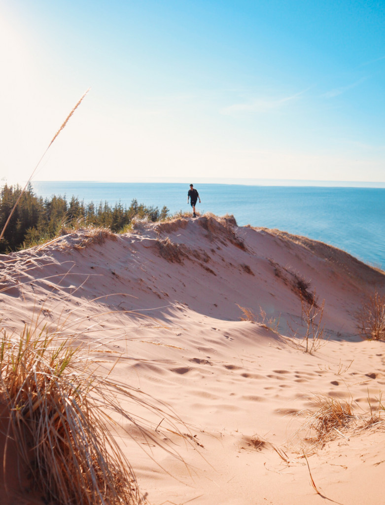 panoramic view overlooking the Grand Sable Dunes
3.5 Chapel Rock and Chapel Falls: Natural Wonders
The Chapel Rock and Chapel Falls area is a highlight of Pictured Rocks, featuring unique rock formations and a picturesque waterfall. The Chapel Basin Loop Trail leads to these natural wonders, offering stunning views along the way. According to the National Park Service, Chapel Rock is one of the most photographed landmarks in the park, known for its unique shape and the single tree that grows atop it.
4. Best Hiking Trails for Seeing Pictured Rocks
Explore these trails to immerse yourself in the beauty of Pictured Rocks, with options for all skill levels.
4.1 Chapel Basin Loop Trail: A Comprehensive Hike
The Chapel Basin Loop Trail is a 10.6-mile hike that offers a comprehensive tour of the park’s highlights, including Chapel Rock, Chapel Falls, and Grand Portal Point. This trail is moderately challenging, with varied terrain and stunning views. The National Park Service recommends allowing at least 5-7 hours to complete the loop, ensuring you have ample time to enjoy the scenery.
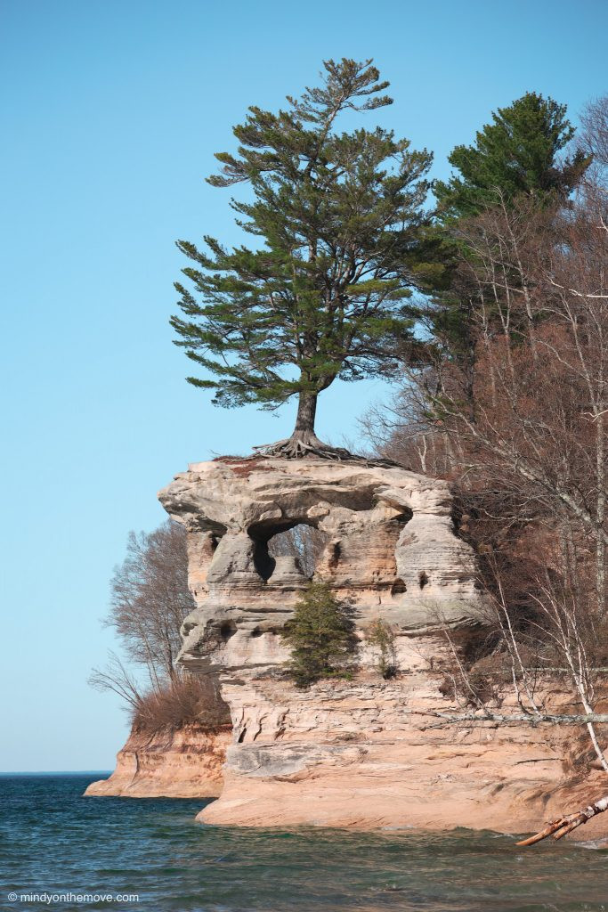 Chapel Rock surrounded by lush greenery and Lake Superior
4.2 Miners Falls Trail: An Easy Waterfall Walk
The Miners Falls Trail is an easy 1.2-mile roundtrip hike to a powerful waterfall. The trail is well-maintained and accessible, making it a great option for families and beginner hikers. The National Park Service highlights Miners Falls as one of the most impressive waterfalls in the park, with a 50-foot drop into a sandstone gorge.
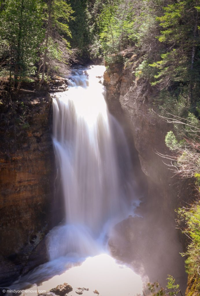 Miners Falls with water cascading down rocks amidst lush greenery
4.3 Sable Falls Trail: A Stairway to Beauty
The Sable Falls Trail is a short but scenic hike down a series of stairs to Sable Falls and Sable Beach. This trail is perfect for a quick visit to a beautiful waterfall and a relaxing stroll along the lakeshore. According to the National Park Service, the stairs can be challenging for some, but the views of Sable Falls and Lake Superior are well worth the effort.
4.4 Sand Point Marsh Trail: Birdwatching Paradise
The Sand Point Marsh Trail is an easy, accessible trail through a coastal marsh, perfect for birdwatching and wildlife viewing. This trail offers a different perspective on the park’s ecosystem, showcasing the diverse plant and animal life of the marsh. The National Park Service notes that the Sand Point Marsh is a critical habitat for migratory birds, making it a prime location for birdwatching enthusiasts.
4.5 Lake Superior Trail: A Coastal Trek
The Lake Superior Trail stretches along the coastline, offering stunning views of the lake and the Pictured Rocks cliffs. This trail can be hiked in sections, allowing you to customize your experience based on your time and fitness level. The National Park Service advises hikers to be prepared for varied terrain and potential hazards, such as slippery rocks and steep drop-offs.
5. Tips for a Safe and Enjoyable Visit
Ensure your trip is memorable for all the right reasons with these essential safety tips.
5.1 What to Wear and Pack for Hiking
Wear comfortable hiking shoes, moisture-wicking clothing, and layers to adapt to changing weather conditions. Pack essentials such as water, snacks, sunscreen, insect repellent, and a map. According to the National Park Service, proper gear is crucial for a safe and enjoyable hiking experience.
5.2 Staying Safe on the Trails
Stay on marked trails, be aware of your surroundings, and carry a first-aid kit. Inform someone of your hiking plans and estimated return time. The National Park Service emphasizes the importance of trail safety, advising hikers to be cautious of wildlife, steep drop-offs, and changing weather conditions.
5.3 Wildlife Awareness: Bears and Other Animals
Be aware of the local wildlife, including bears, and take necessary precautions. Store food properly and avoid approaching or feeding animals. The Michigan Department of Natural Resources provides guidelines for bear safety, advising visitors to make noise while hiking and to carry bear spray in bear country.
5.4 Leave No Trace Principles
Follow Leave No Trace principles to minimize your impact on the environment. Pack out all trash, stay on designated trails, and avoid disturbing vegetation or wildlife. The Leave No Trace Center for Outdoor Ethics promotes responsible outdoor recreation, encouraging visitors to protect natural areas for future generations.
6. Activities Beyond Hiking: Exploring More of Pictured Rocks
Enhance your visit with kayaking tours, boat cruises, and other exciting activities.
6.1 Kayaking Tours: Up-Close Views from the Water
Kayaking tours offer a unique perspective of the Pictured Rocks cliffs, allowing you to paddle along the base of the colorful formations. Several outfitters offer guided tours for all skill levels. According to local tour operators, kayaking is one of the best ways to experience the beauty of Pictured Rocks up close, providing unparalleled views of the cliffs and caves.
6.2 Boat Cruises: A Relaxing Way to See the Cliffs
Boat cruises provide a relaxing and informative way to see the Pictured Rocks cliffs from the water. These cruises typically last 2-3 hours and offer narration about the park’s geology and history. The Pictured Rocks Boat Cruises are a popular option, offering daily tours throughout the summer months.
6.3 Camping Options: From Car Camping to Backcountry
Pictured Rocks offers a range of camping options, from developed campgrounds with amenities to remote backcountry sites for a more wilderness experience. Reservations are recommended, especially during the peak season. The National Park Service provides detailed information about camping options, including regulations, fees, and reservation procedures.
6.4 Fishing and Water Activities
Lake Superior offers opportunities for fishing, swimming, and other water activities. Be sure to check regulations and obtain the necessary licenses. The Michigan Department of Natural Resources provides information about fishing regulations, license requirements, and safety guidelines for water activities.
7. Accommodation and Dining Options Near Pictured Rocks
Find the perfect place to stay and dine during your visit.
7.1 Hotels and Lodges in Munising and Grand Marais
Munising and Grand Marais offer a variety of hotels, lodges, and vacation rentals to suit different budgets and preferences. These towns serve as convenient bases for exploring the park. Popular options include the Roam Inn in Munising and the Grand Marais Inn in Grand Marais, both offering comfortable accommodations and easy access to the park.
7.2 Campgrounds Inside and Outside the Park
Campgrounds are available both inside and outside the park, providing options for tent and RV camping. Reservations are highly recommended, especially during the peak season. The National Park Service operates several campgrounds within the park, including the Twelvemile Beach Campground and the Hurricane River Campground, both offering scenic campsites and convenient access to hiking trails.
7.3 Local Restaurants and Eateries
Enjoy local cuisine at the restaurants and eateries in Munising and Grand Marais. From casual cafes to fine dining establishments, there’s something for everyone. Popular choices include Tracey’s at the Alger Falls in Munising and the Lake Superior Brewing Co. in Grand Marais, both offering delicious meals and a taste of local flavors.
8. Understanding the Geology of Pictured Rocks
Delve into the fascinating geological history of the rock formations.
8.1 How Were the Pictured Rocks Formed?
The Pictured Rocks were formed over millions of years through the erosion of sandstone cliffs by wind and water. The colorful stains are created by mineral deposits, including iron, manganese, and copper. According to geologists at Arizona State University’s School of Earth and Space Exploration, in July 2025, the unique combination of geological processes and mineral-rich groundwater has resulted in the stunning formations we see today.
8.2 The Role of Minerals in the Colors
The vibrant colors of the Pictured Rocks are due to various minerals leaching into the sandstone. Iron oxides create red and orange hues, manganese oxides produce black and brown shades, and copper compounds result in blue and green tones. These minerals seep into the porous sandstone, creating intricate patterns and designs on the cliffs.
8.3 Ongoing Erosion and Preservation Efforts
The Pictured Rocks are constantly being shaped by erosion, with wind and water gradually wearing away the sandstone cliffs. Preservation efforts are in place to protect these natural wonders for future generations. The National Park Service monitors the erosion rates and implements strategies to mitigate the impacts of human activities, such as trail maintenance and visitor education programs.
9. Photography Tips for Capturing the Beauty of Pictured Rocks
Capture stunning images of Pictured Rocks with these photography tips.
9.1 Best Times of Day for Photography
The best times of day for photography are during the golden hours of sunrise and sunset, when the light is soft and warm. These times provide the most flattering light for capturing the colors and textures of the rock formations. Landscape photographers often seek the “golden hour,” when the sun is low on the horizon, creating long shadows and vibrant colors.
9.2 Recommended Equipment
Use a wide-angle lens to capture the panoramic views and a telephoto lens to zoom in on specific details. A tripod is essential for sharp images, especially in low light. According to professional photographers, a versatile lens kit and a sturdy tripod are essential for capturing the beauty of Pictured Rocks.
9.3 Composition Techniques
Use leading lines, rule of thirds, and other composition techniques to create visually appealing images. Pay attention to the foreground, middle ground, and background to create depth and interest. Composition is key to creating compelling photographs, guiding the viewer’s eye through the scene and highlighting the main subject.
10. Frequently Asked Questions (FAQs) About Visiting Pictured Rocks from Land
Find answers to common questions about planning your trip.
10.1 Can You See Pictured Rocks Without a Boat?
Yes, you can see Pictured Rocks from land via numerous hiking trails and overlooks, offering stunning views of the cliffs and Lake Superior. Miner’s Castle and Chapel Rock are popular land-based viewpoints.
10.2 How Much Does It Cost to Enter Pictured Rocks?
There is no entrance fee to enter Pictured Rocks National Lakeshore, but some activities like camping require permits and fees. Check the National Park Service website for current fee schedules.
10.3 Are There Guided Tours Available?
Yes, guided hiking tours and boat cruises are available, providing in-depth information about the park’s geology, history, and ecology. Local tour operators offer a variety of options.
10.4 What Facilities Are Available at the Park?
The park offers visitor centers, restrooms, picnic areas, and campgrounds. Facilities are located throughout the park, with visitor centers in Munising and Grand Marais.
10.5 Is Pictured Rocks Accessible for People with Disabilities?
Some areas of Pictured Rocks are accessible for people with disabilities, including the paved trails at Miner’s Castle and parts of the Sand Point area. Check the National Park Service website for accessibility information.
10.6 Can You Swim at Pictured Rocks?
Yes, you can swim at designated beaches, but be aware that Lake Superior’s water can be cold. Miner’s Beach and Sand Point Beach are popular swimming spots.
10.7 Are Pets Allowed at Pictured Rocks?
Pets are allowed in certain areas of the park, but they must be kept on a leash. Check the National Park Service website for pet regulations.
10.8 What Is the Weather Like at Pictured Rocks?
The weather at Pictured Rocks can be unpredictable, with cool temperatures and frequent rain. Be prepared for changing conditions, especially if hiking or camping.
10.9 How Long Should I Spend at Pictured Rocks?
To fully experience Pictured Rocks, plan to spend at least 2-3 days exploring the various hiking trails, overlooks, and attractions. This allows ample time to see the highlights and enjoy the natural beauty of the park.
10.10 What Safety Precautions Should I Take?
Take safety precautions such as staying on marked trails, carrying a first-aid kit, and being aware of wildlife. Inform someone of your hiking plans and check the weather forecast before heading out.
Conclusion
Seeing Pictured Rocks from land offers a unique and accessible way to experience the beauty of this natural wonder. From iconic viewpoints like Miner’s Castle to scenic hiking trails and kayaking tours, there’s something for everyone to enjoy.
Ready to explore Pictured Rocks National Lakeshore? Visit rockscapes.net for more inspiration, detailed information on various rock types, and expert tips for creating your own stunning landscape designs. Discover the perfect stones to bring the beauty of nature into your life.
Address: 1151 S Forest Ave, Tempe, AZ 85281, United States.
Phone: +1 (480) 965-9011.
Website: rockscapes.net.