Embarking on a walk through Daly City might not immediately conjure images of scenic trails, yet this segment of the Bay Area Ridge Trail offers a surprising escape. Unlike typical Ridge Trail sections that cling to ridgelines boasting panoramic San Francisco Bay views, this route meanders through charming residential areas perched atop bluffs overlooking the vast Pacific Ocean. Starting at the dramatic vista point of Mussel Rock, the trail connects a series of quaint neighborhood parks, eventually leading towards the iconic Fort Funston, part of the Golden Gate National Recreation Area. While more of an urban exploration than a wilderness hike, this Daly City walk unveils captivating sights and offers a unique perspective on the coastline. On a day blessed with perfect weather, the experience is truly exceptional.
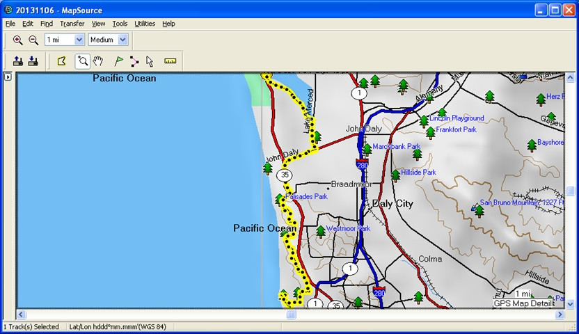 GPS track of Daly City walk starting at Mussel Rock
Mussel Rock Overlook: The Trailhead with a View
The adventure begins at the Mussel Rock Overlook, conveniently located near the intersection of Westline Drive and Skyline Drive in Daly City. Mussel Rock itself is a prominent feature of this coastline, one of several striking rock formations rising from the ocean just offshore. Distinguished as the largest among them, Mussel Rock is also notable for its navigational marker, serving as a landmark for seafarers. These rocks are a haven for gulls and various marine wildlife, adding to the area’s natural appeal. Even with the characteristic coastal fog lingering offshore, the view from Mussel Rock is expansive, although on this particular day, the fog prevented a glimpse of the Farallon Islands on the distant horizon.
Mussel Rock stands as a testament to the dynamic geology of the California coast. These formations are likely remnants of older cliffs, resistant to erosion and sculpted by the relentless power of the Pacific waves. The name “Mussel Rock” hints at the rich intertidal life that these rocks likely support, although observing them from the overlook offers a more panoramic perspective than a close-up ecological study.
Coastal Panoramas: North to Mount Tamalpais and South to San Pedro Point
Turning your gaze northwards along the coastline from Mussel Rock, an unhindered view unfolds towards the majestic Mount Tamalpais. Even at a distance of approximately 18 miles, Mount Tamalpais dominates the horizon, rising above the gracefully curving shoreline where waves rhythmically crash. The visual sweep of the coastline, framed by the grandeur of Mount Tamalpais, is a quintessential California coastal scene.
 View north from Mussel Rock towards Mount Tamalpais and the curving coastline
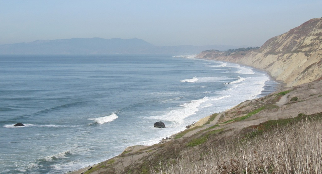
Looking southward from Mussel Rock presents another captivating vista. San Pedro Point and the smaller San Pedro Rock, situated just offshore, become visible in the distance. Located about 5 miles away, these landmarks lie just north of the dramatic Devil’s Slide section of Highway 1. The bluffs closer to Mussel Rock are particularly striking, showcasing both their impressive steepness and the captivating layers of color embedded within their geological composition. The dramatic bluffs, sculpted by time and the elements, contribute significantly to the rugged beauty of this coastal landscape.
Navigating the Bluffs: Elevation and Urban Scenery
The starting elevation at Mussel Rock Overlook is around 150 feet. However, the walk soon reveals the surprising height of the coastal bluffs in this area, reaching up to 600 feet in places and maintaining elevations above 400 feet for a considerable stretch. This elevation change adds a dimension of discovery to what might initially seem like a simple urban walk.
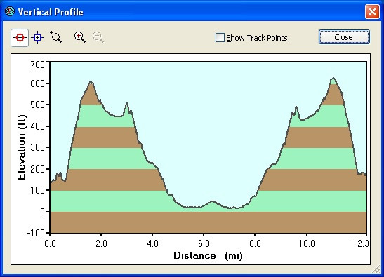 Elevation profile of the Daly City Ridge Trail walk from Mussel Rock
A word of caution for those beginning this walk: after leaving the Mussel Rock parking area, the initial turn can be slightly confusing. Avoid the first stop sign which leads to a waste transfer station. Instead, the correct path involves turning left onto a residential street, initiating a gradual ascent towards the higher bluff area. Following this, the route becomes more clearly marked with Ridge Trail signage. As you ascend through the residential neighborhood, you are treated to charming views of colorful, well-maintained houses lining the steep streets, a unique blend of urban and coastal scenery.
Skyline Drive Vista: Mount Tamalpais and the Golden Gate
Reaching the intersection of Skyline Drive and Oceanside Drive marks the highest point of this Ridge Trail segment. Here, another unobstructed panorama unfolds, showcasing Mount Tamalpais once again, this time framed by the Daly City bluffs and, further in the distance, the iconic Golden Gate. This vantage point highlights the remarkable views enjoyed by the residents of this neighborhood, a daily spectacle when the weather cooperates.
 Panoramic view from Skyline Drive towards Mount Tamalpais, Daly City, and the Golden Gate
Avalon Canyon and Northridge Park: Coastal Erosion and Community Parks
Continuing along the Ridge Trail, the path gradually descends, following the ridgeline of the ocean bluffs. Ridge Trail signs guide you along streets closest to the ocean. Approximately 1.3 miles past Longview Park, you’ll encounter Northridge Park, situated at a curve on Northridge Drive. The route then proceeds along Avalon Drive for about a quarter of a mile, passing Avalon Canyon. This canyon reveals the dramatic impact of storm damage and coastal erosion, where the last row of houses, if they ever existed, has been lost to the elements. Looking down Avalon Canyon from the sidewalk, you can witness waves crashing on the beach below, framed by native “paintbrush grass” – a testament to the raw power of the coastal environment juxtaposed with the resilience of the urban landscape.
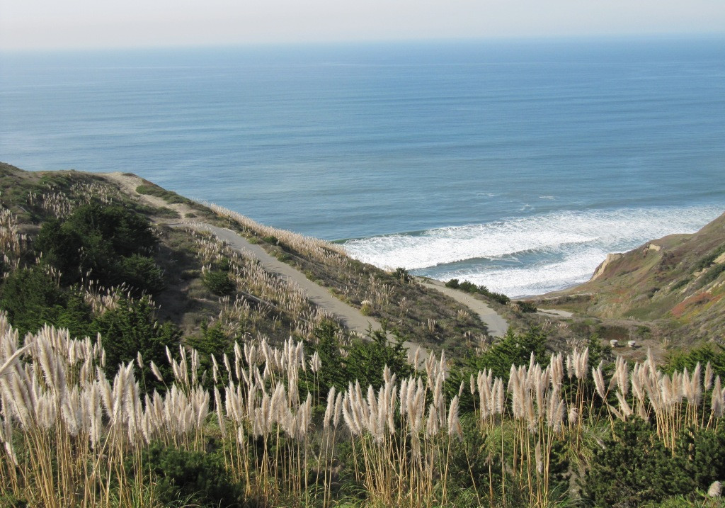 View into Avalon Canyon showcasing coastal erosion and the Pacific Ocean
Palisades Park and Colorful Daly City Homes
About 1 mile beyond Northridge Park, and 3 miles from the starting point at Mussel Rock, lies Palisades Park, marking the end of the direct ocean views along this segment. The Ridge Trail continues its descent, following Westridge Drive across Skyline Boulevard (CA-35) to Mayfair Drive. Mayfair Drive acts as a frontage road to the busier Skyline Boulevard and John Daly Boulevard. In this area, the characteristic colorful houses of Daly City become even more prominent. While architectural designs might share similarities, the vibrant color palettes of these homes create a unique visual tapestry, adding character to the urban trail.
Lake Merced and Journey’s End Near Fort Funston
At the Westlake Shopping Center corner, the Ridge Trail turns left, guiding you along Lake Merced Boulevard towards the southern end of Lake Merced. This peaceful park area provides a tranquil contrast to the urban surroundings. Reaching the south end of the lake signifies leaving Daly City and entering San Francisco.
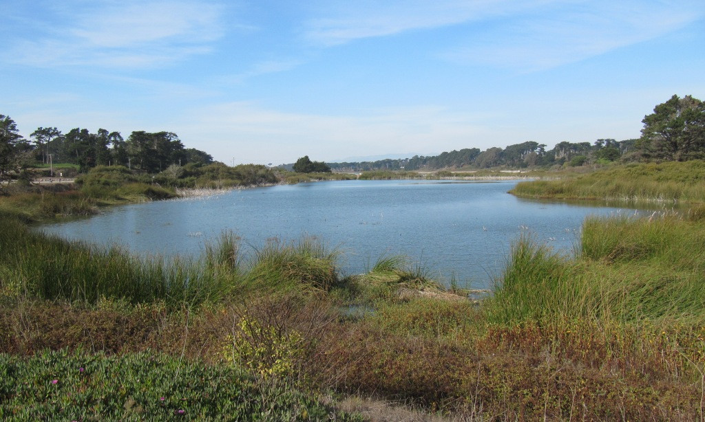 View of Lake Merced from its southern end, a peaceful urban park
The trail continues along the western shore of Lake Merced for just over a mile, until it intersects Skyline Boulevard near Fort Funston. Approaching Fort Funston, the sounds of target shooting from a nearby facility could be heard. Having previously explored the Ridge Trail from Fort Funston northwards into San Francisco, this point marked a natural turnaround.
Sunset at Thornton Beach Overlook: A Perfect Finale
Retracing the route back towards Mussel Rock offered a different perspective under the afternoon light. The marine layer, a common coastal phenomenon, began to reform closer to shore as the afternoon progressed. By the time Mussel Rock trailhead was in sight, sunset was approximately 1.5 hours away. At Longview Park, the fog bank had advanced considerably, becoming denser and greyer, yet the ocean surface still reflected the sunlight beautifully, creating a dynamic interplay of light and atmosphere.
Extending the walk slightly after reaching the car, a short drive to Thornton Beach Overlook, just a couple of blocks from the Ridge Trail route at Skyline Boulevard and John Daly Boulevard, proved worthwhile. This overlook, graced by a solitary Monterey cypress perched on the bluff, provided an ideal vantage point to witness the sunset. From this slightly elevated position, the gradual disappearance of the sun into the thickening marine layer offered a serene and picturesque conclusion to the Daly City walk.
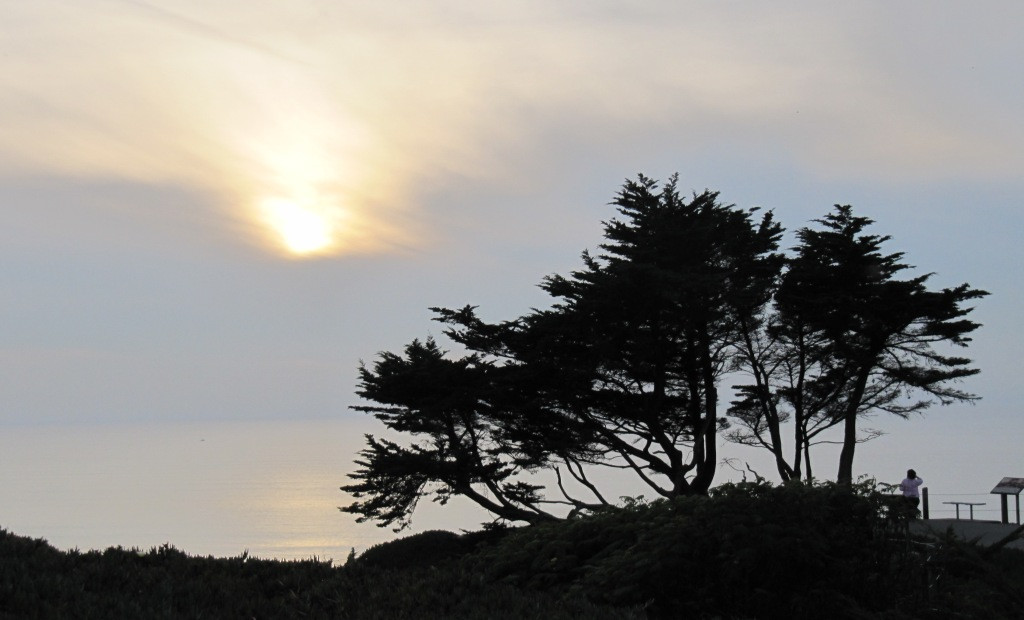 Approaching sunset viewed from Thornton Beach Overlook, Daly City
This walk through Daly City neighborhoods, beginning at the iconic Mussel Rock, serves as a reminder of the Ridge Trail’s surprising proximity to urban life. A brief conversation with a local in one of the neighborhood parks highlighted the appreciation for good weather and the importance of seizing opportunities to enjoy the outdoors. This Daly City Ridge Trail segment, anchored by the striking presence of Mussel Rock, offers a unique blend of urban exploration and coastal beauty, making it a rewarding experience for those seeking unexpected natural escapes within the Bay Area.