Bell Rock stands as one of Sedona’s most recognizable and photographed landmarks, beckoning adventurers and nature lovers alike. This distinctive red rock formation isn’t just a feast for the eyes; it also offers a fantastic, relatively short hike with rewarding panoramic views. For those seeking a bit more thrill, Bell Rock presents opportunities for scrambling higher up its slopes and exploring the spires near the summit. However, be warned: the popularity of Bell Rock means the trail can get crowded, and parking can be a challenge, especially during peak seasons. This comprehensive guide will equip you with everything you need to know for a memorable Bell Rock Hike.
Planning Your Bell Rock Hike
Navigating the trailhead and understanding parking are crucial first steps for a successful bell rock hike.
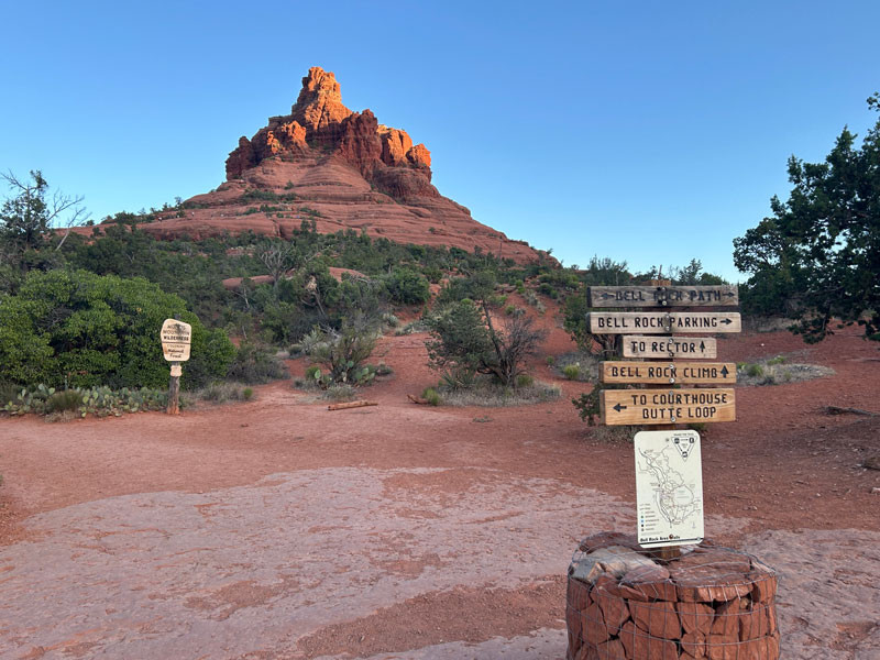
Getting to the Trailhead and Parking at Bell Rock
Parking near Bell Rock can indeed test your patience, a common theme for popular Sedona trails. Due to its easy access and stunning scenery, Bell Rock attracts considerable crowds. While some visitors resort to parking in no-tow zones (not recommended!), a safer and sanctioned option is the overflow parking at Yavapai Point Trailhead, situated about half a mile north on the highway to your left. While a path along the highway is indicated on maps, walking alongside the road isn’t ideal.
Your best strategy is patience. Parking spots turn over frequently, so with a bit of persistence, you’re likely to snag a spot within approximately 15 minutes – often less time than trekking from Yavapai Point.
Trail Options: Bell Rock Access Trail and Bell Rock Climb
Once parked, locate the Bell Rock Access Trailhead. You’ll find it easily: it’s wide, clearly signposted, and usually bustling with fellow hikers.
Hikers on Bell Rock Access Trail, Sedona, Arizona, showcasing the trail’s accessibility and popularity.
As you progress on the Bell Rock Access Trail, you’ll soon encounter a trail junction. Fortunately, the area is well-marked with signs and cairns, ensuring you stay on course. To ascend Bell Rock itself, follow signs for “Bell Rock Climb.” It’s important to note the distinction from the “Bell Rock Path,” which traverses the base of the rock without ascending it. For the bell rock hike that takes you up the formation, “Bell Rock Climb” is your designated route.
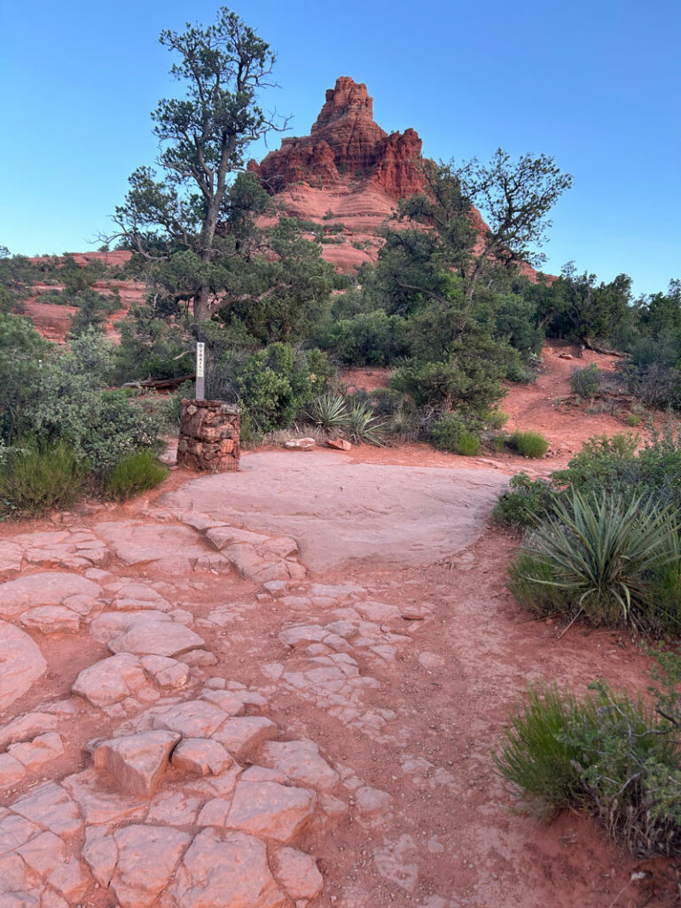
 Trail to the Bell Rock Climb
Trail sign directing hikers to Bell Rock Climb, ensuring clear navigation on the Bell Rock hiking trails.
What to Expect on the Bell Rock Hike
The initial section along the Bell Rock Access Trail is relatively flat and easy, suitable for hikers of most abilities. As you transition to the Bell Rock Climb, the terrain becomes more challenging. Expect steeper inclines and rocky surfaces. The climb is moderately strenuous, and while short, can feel more demanding as you ascend.
The duration of the bell rock hike varies depending on how high you choose to climb. Reaching the initial viewpoints takes roughly 1-2 hours round trip. For those venturing to the spires, allow additional time. The trail is popular throughout the day, so expect to share the path with other hikers. The reward, however, is well worth the effort: breathtaking 360-degree views of Sedona’s stunning red rock landscape unfold as you gain elevation.
What to Bring for Your Bell Rock Hike
To ensure a safe and enjoyable bell rock hike, pack these essentials:
- Water: Especially crucial in the Arizona desert, bring plenty of water to stay hydrated.
- Hiking Shoes: Sturdy footwear with good traction is essential for navigating the rocky terrain.
- Red Rocks Pass or America the Beautiful Pass: Required for parking; purchase at the trailhead kiosk or have your pass ready.
- GPS or Trail Map (optional but recommended): While the trail is generally well-marked, GPS can be helpful, particularly if hiking during sunset or in low light conditions.
- Sun Protection: Hat, sunglasses, and sunscreen are vital to shield yourself from the intense Arizona sun.
Experiencing the Bell Rock Climb
Venturing beyond the marked trail onto the Bell Rock Climb elevates the bell rock hike to a more adventurous experience.
Navigating the Bell Rock Climb Trail
Beyond the “Bell Rock Climb” sign, the trail becomes more rugged. Large cairns serve as reliable guides, marking the path as you ascend.
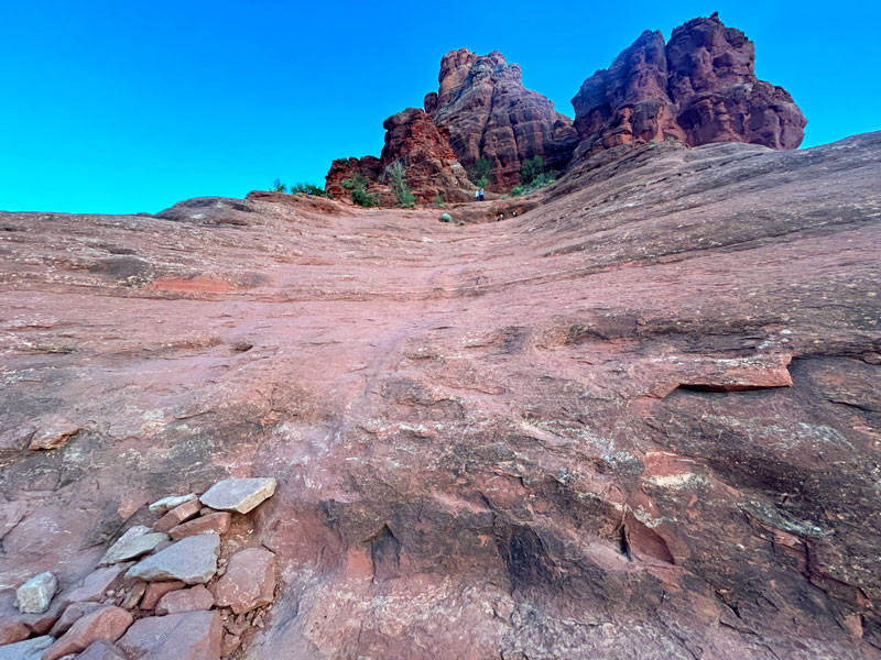
 Trail to the Bell Rock Climb
Cairns marking the Bell Rock Climb trail, essential for navigation on the upper sections of the hike.
The presence of other hikers further confirms you’re heading in the right direction. The trail gradually leads you onto a broad rock platform, which officially marks the end of the mapped trail on most guides. However, the sight of people higher up, near the spires, is an irresistible invitation for many to continue.
The Sketchy Bowl and Upper Levels
The most direct route upwards from the platform involves tackling a rounded, bowl-shaped rock formation. While some helpful hikers may have stacked rocks to create makeshift steps, this section can feel precarious.
 Sketchy spot on the climb up Bell Rock
The “sketchy bowl” section of the Bell Rock Climb, a challenging but navigable part of the upper trail.
Instead of directly ascending the bowl, exploring routes to the left often reveals more manageable paths. A slight detour to the left can lead to spots requiring just a small boost to reach the next level. Teamwork often comes into play here, with fellow hikers lending a hand.
Reaching the Spires and Panoramic Views
Once past the initial challenging section, you’ll discover well-defined use trails leading towards the upper reaches and the spires surrounding Bell Rock’s summit. While reaching the true summit might be uncertain or require technical climbing skills, the views from the spires are undeniably spectacular.
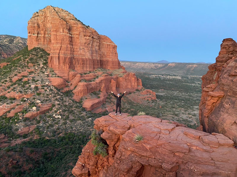 View from a spire on Bell Rock
Sweeping panoramic vista from a spire on Bell Rock, showcasing the stunning red rock scenery of Sedona.
Catching a sunset from this vantage point adds an extra layer of magic to the bell rock hike experience.
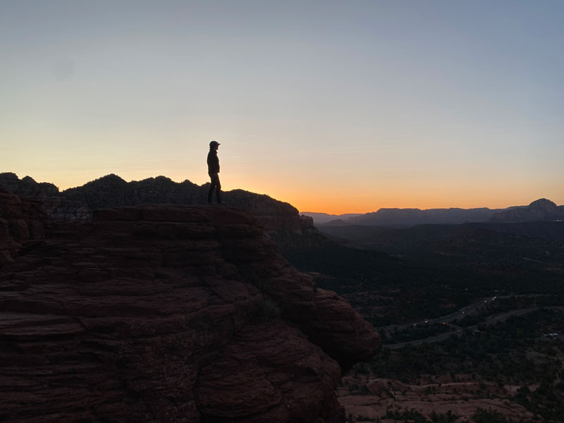 Sunset from a spire on Bell Rock
Sunset hues painting the sky as seen from a Bell Rock spire, a breathtaking reward for hikers.
Descent and Safety Tips
Descending from Bell Rock, especially as daylight fades, requires caution. The tricky sections can feel more manageable going down than up, but it’s still essential to take your time. As light diminishes, the cairns become harder to spot. This is where a GPS device becomes invaluable for staying on the correct path. Pay close attention to trail markers to avoid taking wrong turns, especially in fading light.
Essential Information for Your Bell Rock Hike
Plan your bell rock hike with these practical details:
Location: Munds Mountain Wilderness, Sedona, Arizona
Google Maps: Courthouse Vista (for trailhead directions)
Fees/Passes: A Red Rocks Pass or America the Beautiful Pass is mandatory. Purchase at the self-pay kiosk at the trailhead.
Trailhead Facilities: Pit toilets are available at the trailhead.
Downloadable Maps: Enhance your navigation by downloading KML or GPX trail maps for offline use.
Embark on the bell rock hike and discover the allure of Sedona’s iconic red rock formations. With its accessible trails and awe-inspiring views, Bell Rock promises an unforgettable outdoor adventure.