Sedona’s breathtaking landscapes are famous worldwide, and Bell Rock stands out as one of its most recognizable and photographed landmarks. The Bell Rock Trail offers an accessible and rewarding hiking experience, perfect for those seeking stunning views and a taste of Sedona’s red rock magic. Whether you’re a casual hiker looking for a leisurely stroll or an adventurous spirit wanting to climb higher for panoramic vistas, Bell Rock Trail has something to offer. However, be warned, its popularity means parking can be a bit of a challenge.
Navigating Parking for Bell Rock Trail
Parking in Sedona, especially for popular trails like Bell Rock, often requires patience and planning. You might find yourself circling for a spot, as this trail is a major draw for visitors. While it’s tempting to park in no-parking zones, which we strongly advise against, there is overflow parking available at the Yavapai Point Trailhead. This is located about half a mile north on the highway, on the left side. While a path along the highway is indicated on maps, it’s not the most convenient option.
Your best bet is to exercise a little patience. Parking spots at the Bell Rock Trailhead tend to open up frequently as hikers come and go. With a bit of waiting, you’ll likely snag a spot within 15 minutes, often less time than walking from the Yavapai Point overflow lot. Just keep an eye out and be ready to grab a space when it becomes available.
Starting on the Bell Rock Access Trail
Once you’ve successfully parked, finding the trailhead is a breeze. Head towards the clearly marked Bell Rock Access Trail. You can’t miss it – it’s wide, well-signed, and usually bustling with fellow hikers eager to explore.
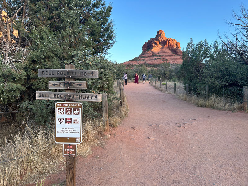 Bell Rock Access Trail in Sedona, Arizona
Hikers on the well-maintained Bell Rock Access Trail, some even dressed up for photoshoots amidst Sedona’s iconic red rocks.
Bell Rock is a hotspot for photographers, so don’t be surprised to see people dressed in their finest attire posing against the dramatic backdrop. Whether you’re in hiking boots or something fancier, you’re in the right place to experience the beauty of Bell Rock.
As you progress along the Access Trail and get closer to Bell Rock, you’ll encounter a trail junction. Fortunately, the trails in this area are well-marked with signs and cairns (stacks of stones), making navigation straightforward. Follow the signs specifically pointing towards “Bell Rock Climb.”
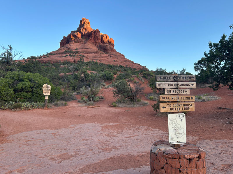 Trail to the Bell Rock Climb
A clear trail sign directs hikers towards the Bell Rock Climb, distinguishing it from the Bell Rock Path which circles the base.
It’s important to note the distinction between “Bell Rock Climb” and “Bell Rock Path.” The “Bell Rock Path” trail circumnavigates the base of Bell Rock, offering views from all sides. However, to actually ascend Bell Rock and reach the viewpoints higher up, you need to follow the signs for the “Bell Rock Climb.”
Ascending the Bell Rock Climb
Beyond the junction for the climb, the trail terrain becomes more challenging and rugged. This is where the real adventure begins as you start your ascent onto Bell Rock itself. Don’t worry, even as the path gets steeper, large cairns are strategically placed to guide you along the most accessible routes.
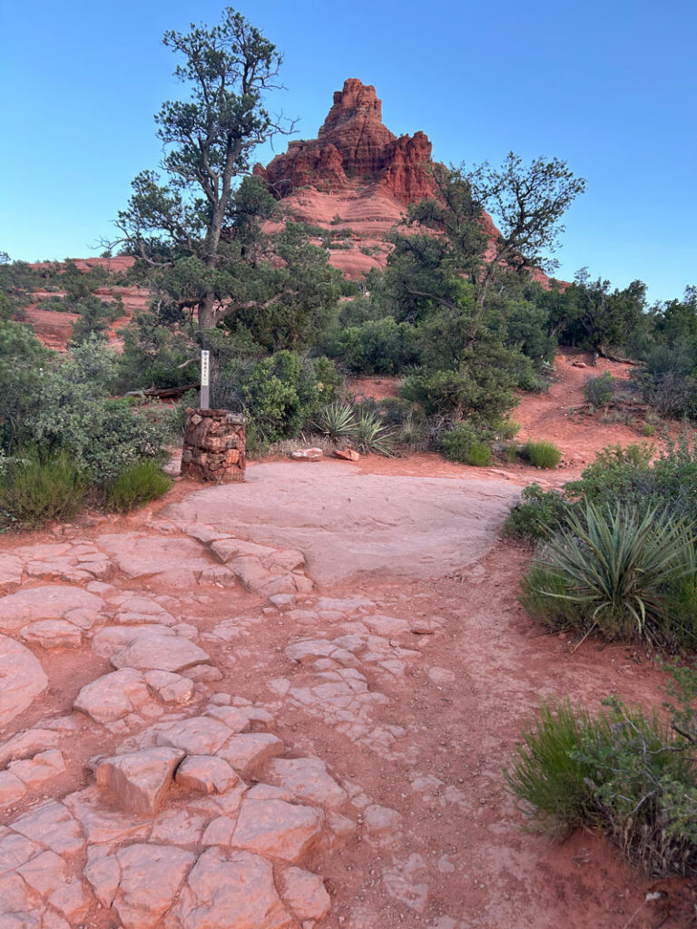 Trail to the Bell Rock Climb
Cairns marking the Bell Rock Climb trail, leading hikers up the rocky slopes with Sedona’s stunning scenery in the background.
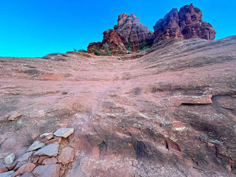
You’ll also likely find plenty of other hikers around, providing a sense of reassurance that you’re heading in the right direction. The trail gradually leads you up onto a broad rock platform. For many casual hikers, this platform often marks the end of the “official” trail as depicted on maps.
However, gazing upwards, you’ll undoubtedly spot people much higher up, near the spires that crown Bell Rock. For those with a taste for adventure and a desire for even more spectacular views, the urge to continue climbing is irresistible.
If you choose to venture further, the most direct route initially appears to be straight up a rounded, bowl-shaped section of rock. On our hike, we encountered some rocks piled as makeshift steps in this area, but personally, I found this route a bit too precarious and exposed for comfort.
 Sketchy spot on the climb up Bell Rock
A steeper, more challenging section of the Bell Rock Climb, where hikers might find the terrain a bit unsettling.
Instead of tackling the “sketchy bowl” head-on, we opted to explore to the left. Going right didn’t seem like a viable alternative. To the left, we discovered a spot that required a small boost to reach the next level. Luckily, we encountered some fellow hikers at this point, who were perhaps questioning their own climbing decisions but were kind enough to lend a hand.
 Climbing up Bell Rock
Hikers assisting each other on a slightly more challenging section of the Bell Rock Climb, showcasing the camaraderie on the trail.
Upon reaching the next level, we found well-defined use trails that circumvented the upper part of the “sketchy bowl” we had previously avoided. By this point, having invested the effort to climb this far, turning back was no longer an option. From here, it became relatively straightforward to reach the spires that encircle the summit area.
We didn’t attempt to reach the absolute summit of Bell Rock, and we’re not even certain if it’s possible without technical climbing gear. However, the views from the spires were absolutely breathtaking and more than rewarding enough.
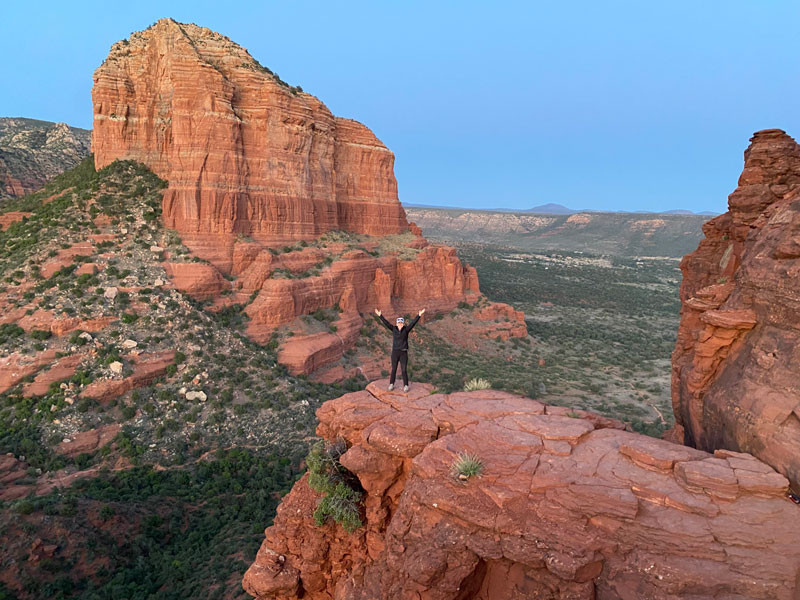 View from a spire on Bell Rock
Panoramic views from one of Bell Rock’s spires, showcasing the vast red rock landscape of Sedona.
Catching a sunset from this vantage point is an extra special treat, painting the already stunning landscape in warm, vibrant colors.
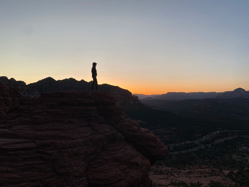 Sunset from a spire on Bell Rock
A stunning sunset view from Bell Rock, with the fiery colors of the setting sun illuminating the red rock formations.
We lingered on the spires until we were the last ones remaining, and as the daylight waned, the descent became a bit more concerning. Getting up had been challenging enough in places. We started heading down quickly, finding the area mostly deserted. Fortunately, descending the trickier sections proved easier than climbing up, and we made it down without any issues.
As the last light faded, the large cairns became harder to spot. If you’re hiking in low light conditions, a GPS device is highly recommended. We actually witnessed some older hikers miss a trail turn and head down the wrong path in the dimming light. It left us concerned for their safety for the rest of our hike.
Hopefully, they found their way back. (Seriously, consider bringing a GPS, just in case!)
Map & Directions for Bell Rock Trail
Location: Munds Mountain Wilderness, Sedona, Arizona
Google Maps: Courthouse Vista (This will take you to the general parking area)
Fees/Passes: You’ll need a Red Rocks Pass or an America the Beautiful Pass. Payment kiosks are available at the trailhead.
Trailhead Facilities: Pit toilets are available at the trailhead.
Download Trail Maps: You can download trail maps in KML or GPX formats for use with GPS devices or apps.