Western North Carolina faced a catastrophic deluge as the remnants of Hurricane Helene unleashed torrential rainfall, leading to unprecedented flooding and widespread damage, particularly impacting communities like Chimney Rock. The relentless precipitation, accumulating over three days, pushed rivers to record levels and submerged entire towns, leaving a trail of destruction across the mountains and southern foothills. For areas like Chimney Rock and Lake Lure, nestled along the Broad River, the flooding was particularly devastating, altering landscapes and lives in an instant.
This extreme weather event is comparable to a Florence-level disaster for the mountainous region, marked by rainfall amounts and subsequent flooding of historic proportions. The sheer volume of water overwhelmed infrastructure, leading to road closures across western North Carolina, with the NC Department of Transportation advising that all roads in the region should be considered impassable. The disaster’s impact is vast and will require years to fully understand and recover from, especially in areas like Chimney Rock where the natural beauty and tourism-dependent economy have been severely affected by the flooding.
While a comprehensive assessment is ongoing, initial reports highlight the factors contributing to this extreme rainfall, the staggering precipitation totals, and the widespread hazards encountered. This event is being compared to some of the worst weather events in the history of the Mountains and the state, forcing a re-evaluation of flood preparedness and resilience in vulnerable communities like Chimney Rock.
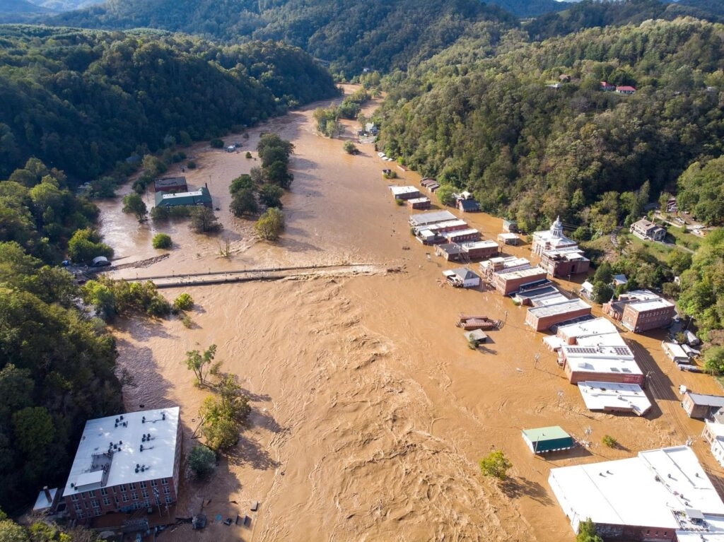 An aerial photo of flooding in downtown Marshall, NC
Alt text: Aerial view of downtown Marshall, NC, submerged in floodwaters after Hurricane Helene, showing the extent of river flooding in the mountain region.
The Perfect Storm: Setup for Unrelenting Rain
The stage for this disastrous flooding was set days before Helene made landfall. On Wednesday, September 25th, while Hurricane Helene was still over the Gulf of Mexico, a stalled cold front stretched from Atlanta into the southern Appalachians. This front, drawing moisture from the distant hurricane, initiated rainfall in areas like Asheville. By Wednesday evening, Asheville was already experiencing steady rain, a precursor to the deluge to come.
As early as Thursday, the Asheville Airport had recorded over 4 inches of rain. River levels in the upper French Broad River basin were already reaching daily record highs, signaling the escalating water levels. The frontal boundary remained stationary, and as Hurricane Helene approached, its outer rain bands merged with the existing system, injecting even more tropical moisture into the atmosphere. Southern Yancey County witnessed over 9 inches of rainfall on Thursday alone, setting the stage for the widespread river flooding that would soon engulf communities downstream, including those along the Broad River leading to Chimney Rock and Lake Lure.
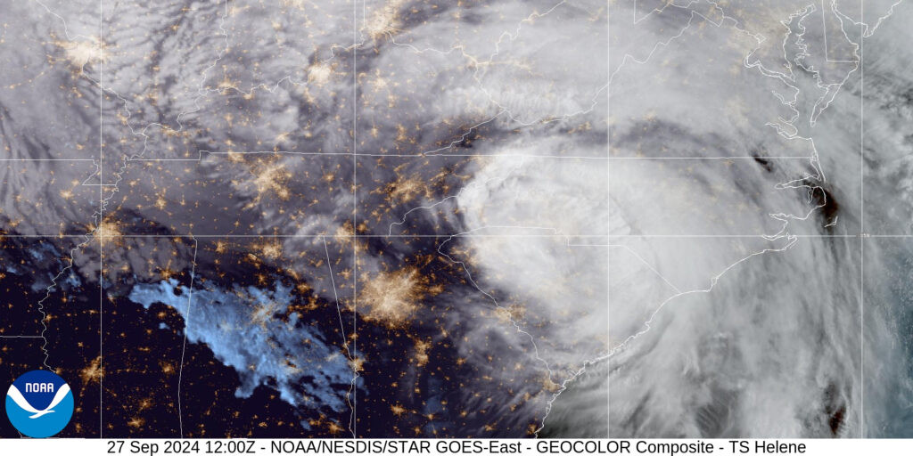 A satellite image of Tropical Storm Helene over the Carolinas on Friday, September 27
Alt text: Satellite image of Tropical Storm Helene positioned over the Carolinas on Friday, September 27th, illustrating the storm’s vast size and its impact on the region.
The sheer size of Hurricane Helene amplified its impact. Formed in a high-humidity environment over the unusually warm Gulf of Mexico, the storm intensified and expanded, creating a vast southeasterly circulation. This circulation acted like a firehose, pushing moisture-laden air directly into the saturated mountain slopes of Western North Carolina. From the initial frontal showers on Wednesday to the peak of Helene’s passage on Friday morning, the region endured an extraordinary and devastating weather event.
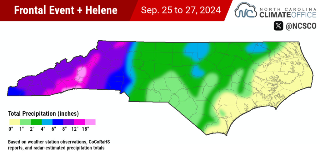 A map of total precipitation from the precursor frontal event and Hurricane Helene in North Carolina
Alt text: Precipitation map of North Carolina showing total rainfall accumulation from the precursor frontal system and Hurricane Helene, highlighting areas with over 18 inches of rain, including regions near Chimney Rock.
Unprecedented Rainfall and Catastrophic Flooding in Chimney Rock
The three-day period from September 25th to 27th saw rainfall totals exceeding 8 inches across the entire Mountain region. Several areas, including parts of Alleghany County and a stretch from Boone to Brevard, received over a foot of rain. The hardest-hit areas, including southern Yancey County, western McDowell County, southeastern Buncombe County, and northwestern Rutherford County, experienced rainfall exceeding 18 inches. Mount Mitchell recorded an astonishing 24.41 inches, while Bearwallow Mountain measured 19.99 inches. The highest unofficial total came from Busick, reporting a staggering 31.33 inches of rain over three days. These extreme rainfall amounts directly contributed to the devastating flooding in Chimney Rock and surrounding areas.
Volunteer weather observers also confirmed these extreme totals, with Spruce Pine reporting 24.12 inches, Foscoe 22.36 inches, and areas near Black Mountain and Hendersonville exceeding 22 inches. Numerous weather stations across the region recorded their wettest three-day periods ever.
| Station | County | Sep. 25 | Sep. 26 | Sep. 27 | 3-Day Total |
|---|---|---|---|---|---|
| Busick RAWS | Yancey | 6.35 | 10.07 | 14.91 | 31.33 |
| Mount Mitchell ECONet | Yancey | 5.09 | 9.32 | 10.00 | 24.41 |
| Bearwallow Mtn. ECONet | Henderson | 3.40 | 6.10 | 10.49 | 19.99 |
| Celo 2 S | Yancey | 0.46 | 7.63 | 11.89 | 19.98 |
| Sparta 2 SE | Alleghany | 1.08 | 3.98 | 10.23 | 17.29 |
| Laurel Springs ECONet | Ashe | 1.59 | 9.95 | 5.47 | 17.01 |
| Boone 1 SE | Watauga | 1.95* | 7.65* | 7.07* | 16.67 |
| Frying Pan Mtn. ECONet | Haywood | 2.80 | 8.61 | 4.67 | 16.08 |
| Old Fort Ag 3 W | McDowell | 6.30* | 6.30* | 2.95* | 15.55 |
| Asheville Airport | Buncombe | 4.09 | 5.78 | 4.11 | 13.98 |
| Tryon | Polk | 3.02 | 5.01 | 4.94 | 12.97 |
| Marion 2 NW | McDowell | 3.54* | 6.02* | 3.21* | 12.77 |
Table: Notable rainfall totals from September 25th to 27th across Western North Carolina, highlighting record-breaking amounts during Hurricane Helene.
This extreme rainfall caused rivers across the region to swell to dangerous levels. The Watauga, Catawba, Swannanoa, and French Broad rivers all reached or exceeded major flood stages, inundating communities in their path. Downtown Boone was submerged under several feet of water, requiring swift water rescues. Morganton experienced significant flooding as the Catawba River, reaching record levels, overflowed into the city. Buncombe County officials described the devastation as “biblical,” with Asheville largely cut off and surrounding communities like Swannanoa and Black Mountain under water.
Chimney Rock and Lake Lure were particularly hard hit. The Broad River surged with destructive force, unleashing a torrent of water, mud, and debris into these towns. Homes and businesses in Chimney Rock were reduced to wreckage. As the water level at Lake Lure Dam rose perilously, exceeding its capacity, downstream evacuations were ordered due to concerns of potential dam failure.
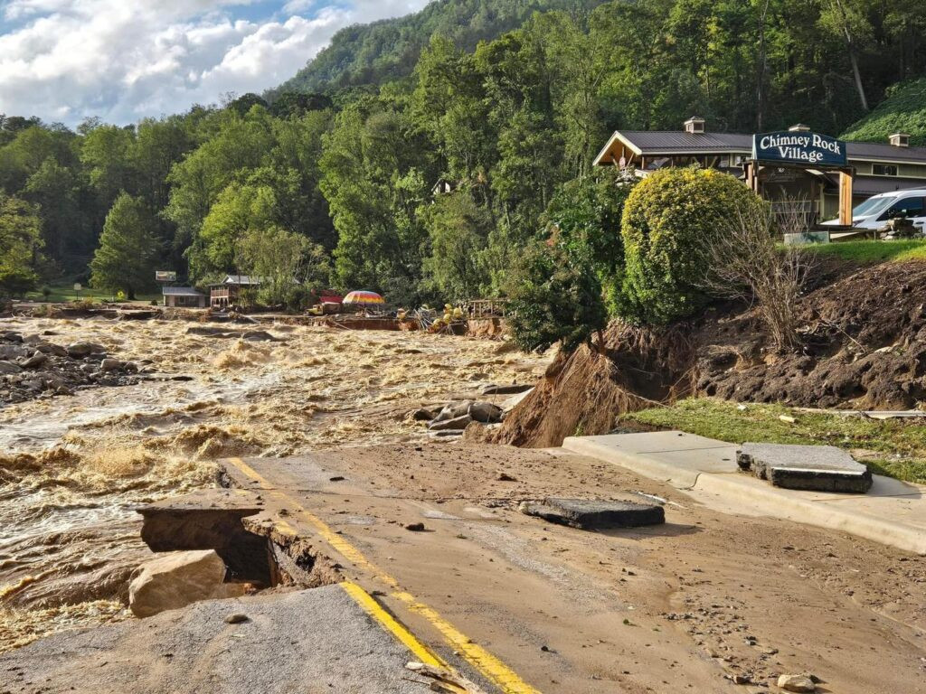 A photo of flooding and damage in downtown Chimney Rock
Alt text: Extensive flood damage in downtown Chimney Rock, North Carolina, following Hurricane Helene, showing debris-filled streets and inundated buildings.
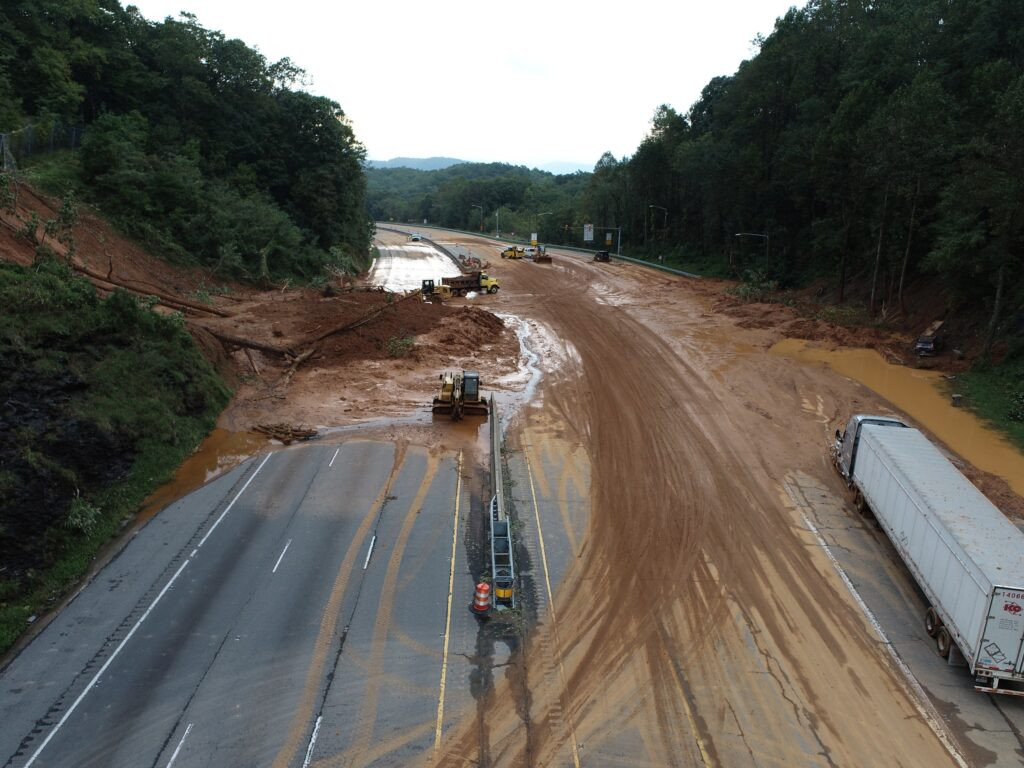
Similar evacuation orders were issued downstream of Waterville Dam in Haywood County and along parts of Mountain Island Lake as the Catawba River system dealt with massive water volumes. Landslides and mudslides further compounded the disaster, blocking Interstate 40 in McDowell County and disrupting roadways throughout the mountainous terrain, including areas near Brevard. The picturesque landscapes of waterfalls and fall foliage were replaced by scenes of destruction and devastation in areas like Chimney Rock.
Wind Damage and Tornadoes Add to Mountain Misery
Beyond the catastrophic flooding, Hurricane Helene brought strong winds to North Carolina, impacting even the mountainous regions. Tropical storm-force gusts were recorded across the Mountains, Piedmont, and southern Coastal Plain. Charlotte Airport recorded a 66 mph gust, the strongest since 2019. On Mount Mitchell, a staggering 106 mph gust was measured, the strongest wind there since 2011. Frying Pan Mountain recorded its highest ever wind gust at 87 mph.
These powerful winds led to widespread power outages throughout western North Carolina. Duke Energy reported over 700,000 customers without power in North Carolina on Friday morning. Even days after the storm, hundreds of thousands remained without electricity, hindering recovery efforts in communities already reeling from the floods, including Chimney Rock.
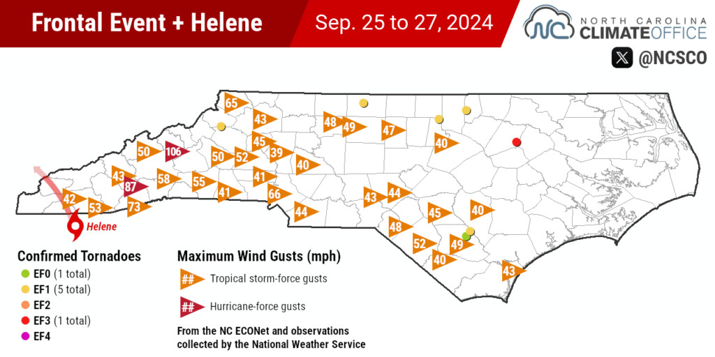 A map of wind gusts and confirmed tornadoes from the precursor frontal event and Hurricane Helene in North Carolina
Alt text: Map showing significant wind gusts and confirmed tornado locations across North Carolina during Hurricane Helene and the precursor weather system, illustrating the widespread wind impacts.
Adding to the storm’s destructive nature, Hurricane Helene spawned several tornadoes across the state. Six tornadoes were confirmed on Friday, and a rare mountain tornado struck near Blowing Rock on Wednesday evening, the first in Watauga County since 1998. The strongest tornado, rated EF3, struck Rocky Mount, causing significant damage and injuries.
The combined impact of flooding, wind damage, and tornadoes resulted in a major disaster. Over 200 people were rescued from floodwaters, but hundreds more rescue calls and welfare checks were requested. Tragically, the death toll continued to rise as rescue and recovery efforts progressed, with Buncombe County alone reporting a grim figure. The statewide death toll threatened to approach the devastating levels seen in the region’s historic July 1916 flood.
 A photo of a tree and power line across a roadway in Asheville
Alt text: Fallen tree and downed power lines blocking a road in the Asheville area, demonstrating the widespread wind damage from Hurricane Helene that contributed to power outages.
Helene: The New Flood of Record for Western NC, Surpassing 1916
Western North Carolina has a history of heavy rainfall and flooding, often exacerbated by its mountainous terrain. While tropical systems are less frequent here than on the coast, they can become extreme rainfall events when moisture-laden air is forced upwards by the mountains. Tropical Storm Fred in 2021 caused deadly flooding in Haywood County, serving as a recent reminder of the region’s vulnerability.
However, Hurricane Helene surpassed even Fred in its scale and devastation. The National Weather Service issued an unprecedented number of Flash Flood Emergencies across 21 counties during Helene, compared to just one during Fred. Many long-time residents recalled the floods of September 2004, caused by the tropical trio of Frances, Ivan, and Jeanne, which had previously marked the wettest month on record for many areas. But September 2024, driven by Helene, exceeded those records, establishing itself as the new wettest month ever in places like Asheville and Sparta.
The French Broad River in Fletcher crested an astonishing ten feet higher than its previous record set during the 2004 floods. For the southern Mountains, the closest historical comparison is the July 1916 flood, long considered the region’s flood of record. But Helene has now surpassed the 1916 flood in scale and impact. The increased development in the mountain landscape since 1916 means the damage from Helene is projected to far exceed the inflation-adjusted $641 million in damages from the 1916 storm, potentially reaching levels comparable to Hurricane Florence’s $17 billion in statewide damage.
 A photo of a landslide along Interstate 40 in Buncombe County
Alt text: Landslide covering Interstate 40 near Black Mountain, Buncombe County, highlighting the ground saturation and instability caused by the extreme rainfall from Hurricane Helene.
River gauges that recorded both the 1916 flood and Helene showed record crests during Helene’s passage. The French Broad and Swannanoa Rivers, which converged to devastate Biltmore Village in 1916, both reached new record heights. In Asheville, the French Broad River rose 1.5 feet above its previous record. Downstream, it surpassed its 1916 crest and was still rising when the gauge failed. The Swannanoa River at Biltmore crested over five feet above its 1916 level, marking the worst flood on that river since North Carolina became a state.
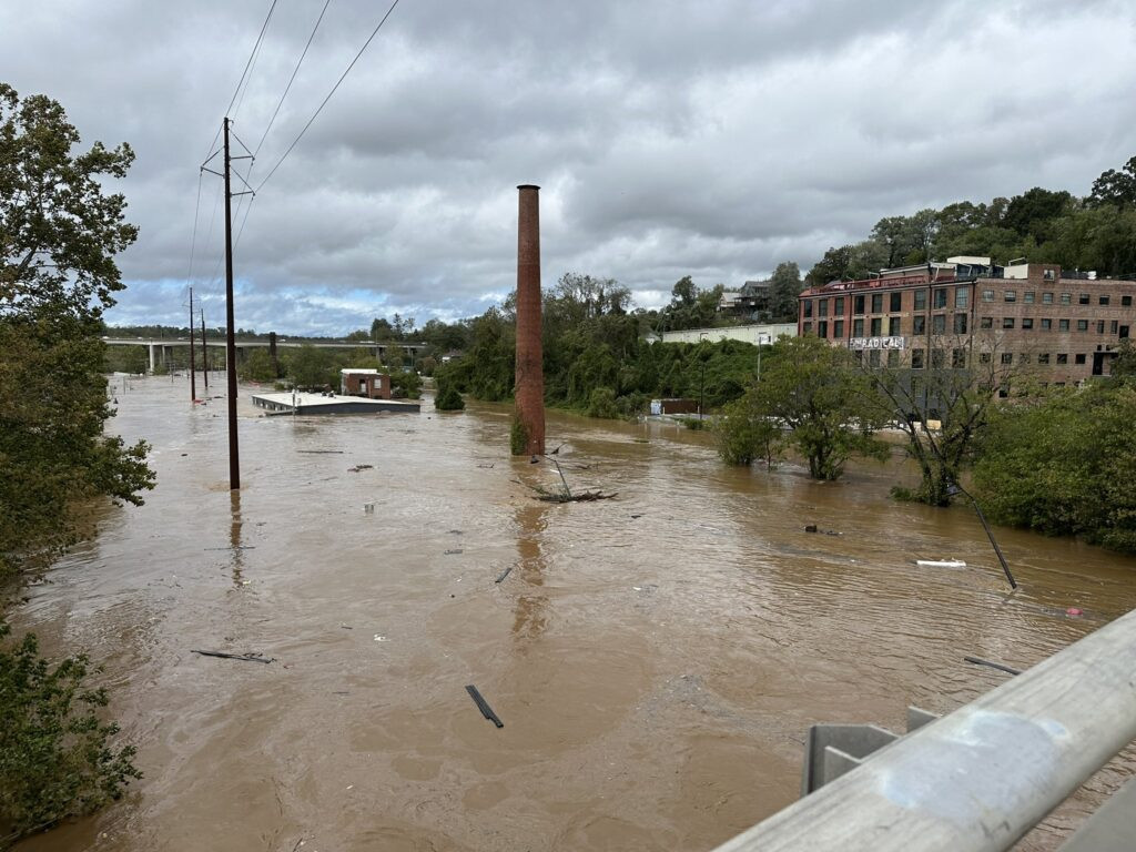 A photo of flooding in Asheville following Helene
Alt text: Flooding at The Asheville Cotton Mill in the River Arts District after Hurricane Helene, showing the impact of record river levels in urban areas.
A Historic Storm in a Changing Climate
Hurricane Helene’s extreme rainfall and flooding in Western North Carolina are part of a pattern of increasingly intense weather events. Just weeks prior, another heavy rain event, associated with Potential Tropical Cyclone Eight, brought over 20 inches of rain to eastern North Carolina. The widespread flooding caused by Helene echoes the devastation seen after Hurricanes Matthew (2016) and Florence (2018) in eastern parts of the state, with major cities like Wilmington then and Asheville now cut off by floodwaters.
Rainfall return intervals, used to assess the rarity of such events, indicate the extreme nature of Helene. The daily rainfall in Celo reached a 1-in-500 year level. In Asheville, the three-day rainfall total exceeded the 1-in-1000 year level. And the 24.41 inches at Mount Mitchell far surpassed even the 1-in-1000 year amount for a three-day period.
This succession of extreme weather events provides further evidence of a changing climate. The rapid intensification of Helene, the abundant moisture in its environment, and the resulting historically unprecedented rainfall are all consistent with the effects of a warmer atmosphere. While predicting the frequency of future storms remains challenging, the increasing intensity of rainfall and flooding events is a growing concern.
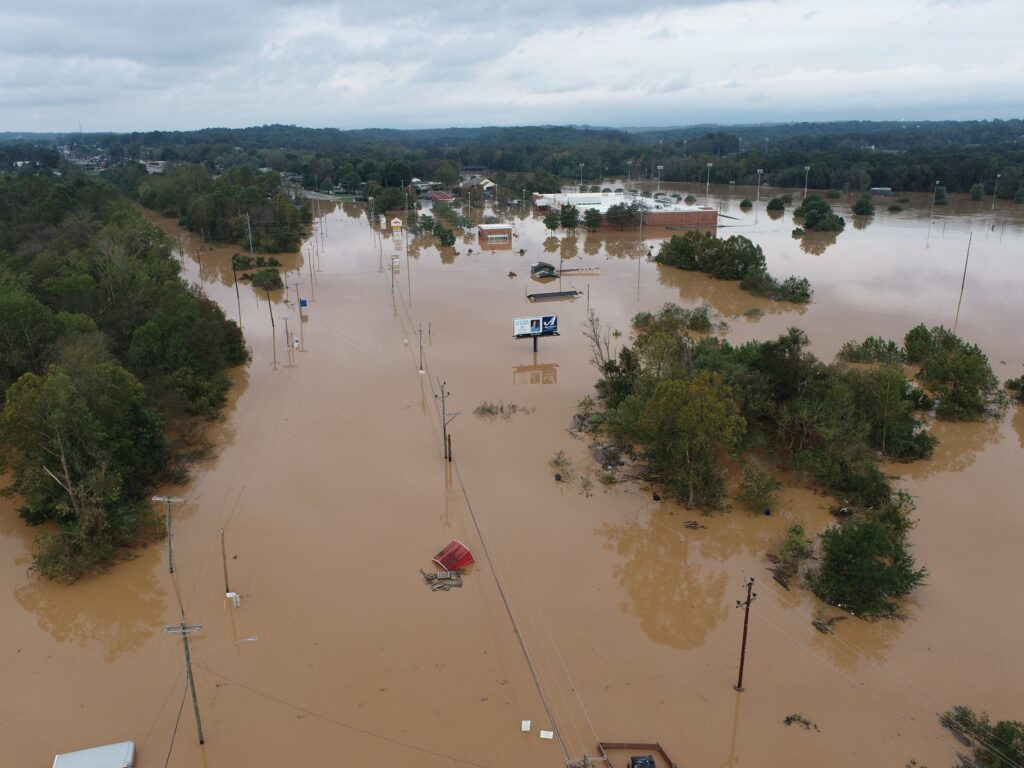 An aerial photo of flooding in Silver Creek after Helene
Alt text: Aerial view of flooding along Highway 70 near Silver Creek in Burke County after Hurricane Helene, illustrating the widespread river and highway flooding.
Due to its devastating impact in Florida and North Carolina, the name Helene is likely to be retired by the World Meteorological Organization. Ironically, a previous Hurricane Helene in 1958 narrowly missed North Carolina, offering a “what-if” scenario. This time, 66 years later, there was no escape from the destructive force of Hurricane Helene, a storm that will be remembered as a historic and tragic event for Western North Carolina, especially for communities like Chimney Rock grappling with the immense challenges of recovery.
A note from our director and state climatologist, Dr. Kathie Dello:
The destruction from Hurricane Helene in western North Carolina has been distressing to watch — much more so for those who are waiting to hear from family and friends in the region. As a public service center for the state, our office wants to share not only the story of the storm, but also how to assist in the recovery.
The best way to support cleanup and recovery efforts is through the North Carolina Disaster Relief Fund, which is accepting donations that go directly to nonprofits working in impacted communities. As of October 7, several organizations are seeking volunteers to help in affected areas. If you’re inclined to help in person, make sure you’ve submitted an application and/or been given an assignment before arriving in areas still cleaning up from the storm.
Rapid Reaction: Unnamed Storm Unleashes Torrential Rain in Eastern NC
Reflecting on a Record-Setting, Storm-Soaked September