Nestled in the heart of Gananoque, Ontario, the Marble Rock Conservation Area offers an unforgettable hiking experience for nature enthusiasts of all levels. As content creators at rockscapes.net, we’re always on the lookout for trails that combine natural beauty with unique geological features, and Marble Rock certainly delivers. On a quest to explore more of the Gananoque region, we ventured to Marble Rock at the first hint of spring, and what we discovered was a hidden gem worthy of every hiker’s bucket list. Part of the renowned Rideau Trail network, specifically marked as a Blue Loop, Marble Rock promises well-maintained trails and meticulously planned routes, a hallmark of the Rideau Trail designation.
Located conveniently under two hours from Ottawa, Marble Rock Conservation Area is an ideal destination for a day trip or a weekend getaway. The area boasts a network of trails, featuring two interconnected loops that cater to different hiking preferences and abilities. Whether you’re seeking a shorter, invigorating walk or a more extended exploration, Marble Rock has something to offer.
Before our visit, we spent time searching online for practical information, particularly regarding pet policies and year-round accessibility. Finding limited details online, we decided to bring our dog along, prepared with a backup plan just in case. Upon arrival, we were pleased to find no signage prohibiting dogs, suggesting a welcoming environment for four-legged companions. Similarly, the absence of seasonal closure notices led us to believe that Marble Rock Conservation Area welcomes visitors and their canine friends throughout the year.

Alt text: Hikers ascending a rocky uphill section of the Marble Rock Conservation Area trail, showcasing the diverse terrain.
Getting to Marble Rock: Directions and Accessibility
Navigating to Marble Rock Conservation Area requires a bit more precision than simply relying on generic GPS directions. We initially trusted Google Maps, which unfortunately led us on a slight detour past the Conservation Area to Gananoque Lake, adding approximately 10 kilometers to our journey. To ensure a direct route, we highly recommend using the following GPS coordinates: 44.393217, -76.154164. These coordinates will guide you directly to the parking area.
As you approach Marble Rock, the paved roads gradually transition to well-maintained dirt roads. These roads are generally wide and in good condition, with minimal potholes, and are surrounded by residential properties, suggesting regular winter maintenance and plowing.
The entrance to the Conservation Area is marked by a modest sign positioned beside the road, leading to an unassuming parking lot. The parking area offers space for around fifteen to twenty vehicles. During our visit, we were the only ones there, highlighting the tranquil and less crowded nature of this hiking destination, especially during off-peak times.

Alt text: The Marble Rock Conservation Area sign, marking the entrance to the hiking trails and parking lot.
In terms of facilities, the parking area is quite basic, lacking amenities. However, the town of Gananoque, with its full range of services, is just a short ten-minute drive away. If you require restrooms, refreshments, or any last-minute supplies before your hike, it’s advisable to stop in Gananoque before heading to the Conservation Area.
Exploring the Marble Rock Trails: North and South Loops
The trailhead for both the North and South Loops is conveniently located adjacent to the parking lot, near the road entrance. A trail map is posted at the trailhead, providing a clear overview of the route options.
Our hike began alongside the road for a short distance, approximately 100 meters, before veering left into the encompassing forest. Almost immediately, we started to ascend gently, with hills that were challenging yet manageable.
Just 0.5 kilometers into our hike, a signpost directed us to the Leaning Rock Lookout. Intrigued, we took the short detour. This initial lookout offers a glimpse of the scenic views that await further along the trail.

Alt text: A well-marked sign indicating the direction to a lookout point along the Marble Rock hiking trail.
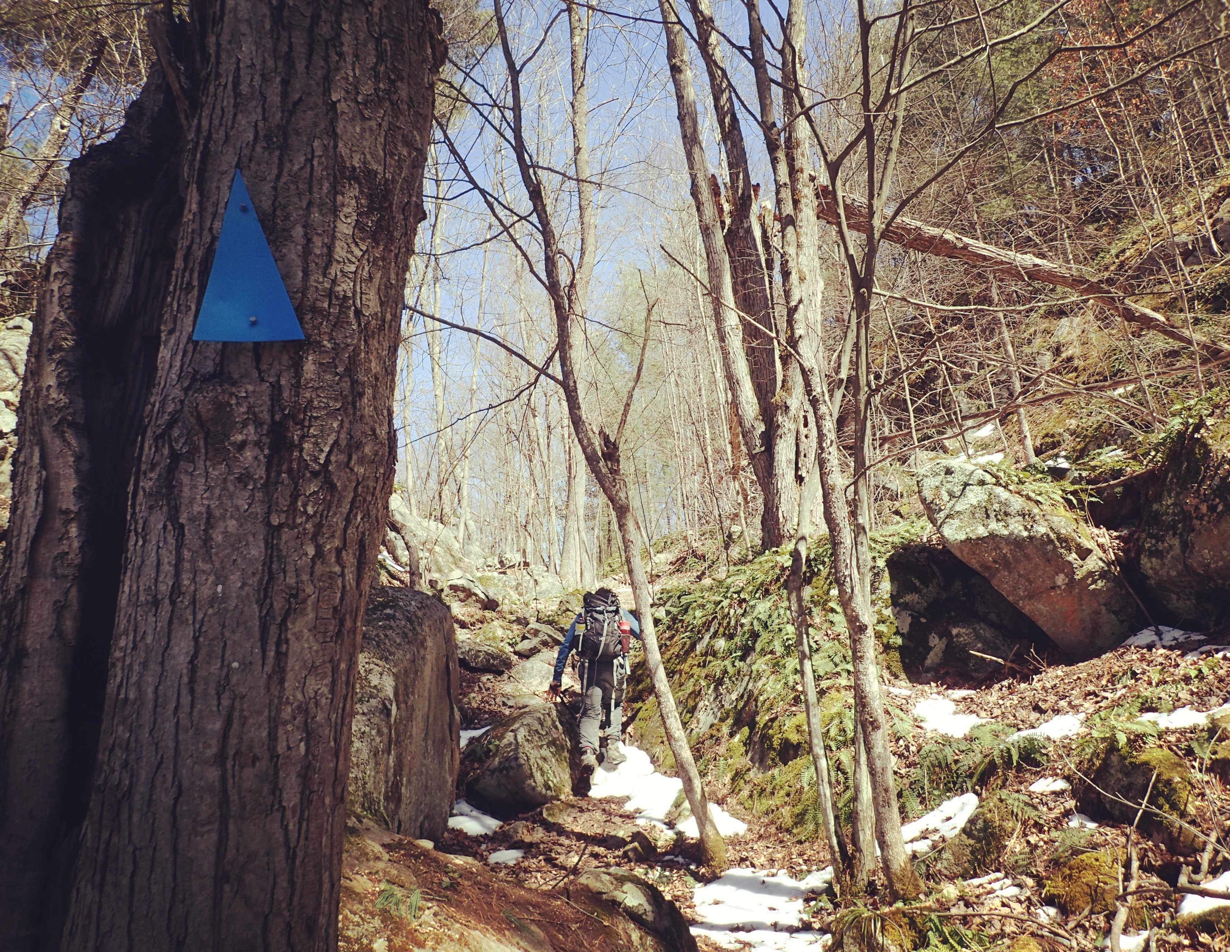
Soon after the first lookout, we encountered what became our favorite section of the trail. This segment involved navigating and scrambling over and around large, impressive rocks, leading to a small rise and the main lookout points. Upon reaching the summit of the hill, we were delighted to discover not one, but two lookout points, positioned to the left and right.
While the views from these lookouts might be considered somewhat modest, particularly in early spring before full foliage, the experience of reaching them, navigating the rocky terrain, was truly enjoyable. We imagine these vistas become even more vibrant and picturesque during the summer and fall seasons.

Alt text: Hikers navigating a section of the Marble Rock trail characterized by large rocks and natural terrain.
The South Loop: Challenging Terrain and Scenic Vistas
The first major trail junction appears just before the 1-kilometer mark. Having consulted our map from the Frontenac Arch Biosphere Network, a valuable resource for trail information in the region, we knew that the eastern portion of the South Loop was considered the most challenging part of the entire trail system. Opting to tackle the most demanding section first, we turned right at the junction.

Alt text: A trail map of Marble Rock Conservation Area highlighting the South Loop and North Loop trails, indicating the varying difficulty levels.
The South Loop lives up to its reputation for elevation gain, with consistent ascents throughout this section. However, it’s the terrain, more than the steepness, that presents the primary challenge. Much of the eastern side of the loop is characterized by rocky paths. For hikers who prefer smooth, even surfaces, this terrain demands careful footing and slower progress. For those who enjoy a more rugged and technical hike, the rocky sections are likely to be invigorating and fun.
As we approached the lake, the trail transformed dramatically, widening and flattening into an almost road-like path. Despite searching, we were unable to find a name for this serene lake. The wind coming off the water was noticeably cool, reminding us to appreciate our layers of fleece on what was otherwise a beautiful day. By this point, we had hiked approximately 2.7 kilometers.
Water Features and Creek Crossings
The lake’s outflow is regulated by a man-made dam, creating a small creek that intersected the trail. The creek was narrow enough to jump across, which most of our group managed with relative ease. However, even for those less confident with leaps, the crossing was manageable.
Given the time of year (early spring), we encountered several wet and muddy sections along the trail. Committed to Leave No Trace principles, we chose to navigate directly through the mud and water in the center of the trail, rather than widening the path and potentially damaging surrounding vegetation. While our boots got wet, our commitment to trail preservation remained dry!
Crossing the creek and other water features would likely be even simpler later in the hiking season as water levels recede.

Alt text: A hiker carefully navigating a water crossing on the Marble Rock trail, highlighting the potential for wet conditions.
South Loop Lookout and Trail Junction
Approximately 200 meters past the lake, another signpost marked the detour to the South Loop Lookout. Eager to explore every vista, we followed the side trail. A short walk of a couple hundred meters brought us to an expansive, open rock face. We ventured across the initial rise and paused to take some photos, but the views felt somewhat obstructed from this immediate vantage point. We noticed a friendly couple who had arrived shortly after us enjoying the scenery further along the rock face. Respecting their space and seeking to continue our hike, we retraced our steps back to the main trail.

Alt text: The South Loop Lookout at Marble Rock Conservation Area, offering panoramic views of the surrounding landscape.
Not long after, having hiked a total of 4 kilometers, we reached the junction that marked the beginning of the North Loop. Initially unsure if we would tackle both loops, reaching this point instilled a sense of accomplishment, and we decided to continue onward and explore the North Loop as well.

Alt text: A prominent trail sign clearly marking the junction for the North and South Loops at Marble Rock Conservation Area.
Exploring the North Loop: A Quieter Path
The North Loop is connected to the South Loop via a short, 300-meter connecting trail. This link, while brief, maintained the rocky character of the South Loop.
Before embarking on this connecting section, we decided to give our dog a break and placed her in her backpack carrier. Despite her love for hiking, and her boundless energy, we are mindful of her age and stamina. Having practiced with the backpack at home, she was accustomed to it, but this was her first extended ride. To our amusement, she seemed to thoroughly enjoy the elevated perspective and the rest.

Alt text: A dog comfortably resting in a backpack carrier during a hike on the Marble Rock trails.
Upon reaching the North Loop junction, we continued our pattern and turned right to explore the eastern side of this loop first. Almost immediately, the North Loop presented a different character. It was evident that this trail is less frequented than the South Loop. The path was slightly more overgrown, with more fallen branches and natural debris scattered across the trail.

Alt text: A section of the North Loop trail at Marble Rock Conservation Area, showing a slightly overgrown path with natural ground cover.
Despite being less traveled, the North Loop trail remained easily navigable, with a clear footpath to follow. True to form, the Rideau Trail Association’s excellent trail markers were present and reliable, even in this quieter section.
After hiking approximately 4.6 kilometers, we passed close to the shoreline of another picturesque, unnamed lake, which turned out to be a beaver pond according to nearby interpretive signs. The views across the pond were tranquil and beautiful.
Returning Towards the South Loop
The North Loop maintained a relatively consistent elevation profile, with less significant elevation changes compared to the South Loop. The terrain on this loop was also noticeably less rocky, contributing to its reputation as being somewhat easier than the South Loop.
One notable feature of the North Loop was the prevalence of low-lying, scrubby evergreen bushes lining the trail. While not particularly problematic, they did brush against our legs, making long pants a preferable choice for this section.
Having hiked a total of 7 kilometers, we arrived back at the connecting trail that links the North and South Loops. Rejoining the South Loop, we turned right to complete the remaining section. This part of the trail was also quite damp, with a few small stream crossings. We anticipated these streams likely drying up later in the season.
The Final Stretch and Trailside Ruins
Around the 7.8-kilometer mark, we began to descend in elevation. After hiking a little over 9 kilometers, we encountered intriguing old ruins situated alongside the trail. The substantial foundation suggested a significant structure once stood here, but its original purpose remained a mystery to us.

Alt text: Stone ruins visible along the Marble Rock hiking trail, hinting at the area’s history.
The final section of the trail presented one last obstacle – an enormous fallen tree that completely blocked the path. Appearing recently fallen, we cautiously navigated around and under the tree, successfully bypassing this natural roadblock.

Alt text: A large fallen tree obstructing the hiking trail at Marble Rock Conservation Area, requiring hikers to navigate around it.
After hiking 10 kilometers, we arrived back at the initial junction of the South Loop. Recognizing familiar trail markers, we retraced our steps back to the parking lot. This hike marked our first long trek of the spring season, and carrying our dog for a portion of it added to the physical exertion, leaving us pleasantly tired.
In total, completing both the North and South Loops amounted to a 10.6-kilometer hike. Our total time on the trail was four and a half hours, which included numerous stops for photography, dog-related breaks, and a leisurely lunch.
Alternate Hiking Options: The South Loop as a Shorter Route
Observing the trail conditions and visitor traffic, it was clear that the South Loop is significantly more popular and frequently hiked than the North Loop.
Choosing to hike only the South Loop still provides a rewarding and complete hiking experience. The majority of the elevation changes and more challenging terrain are concentrated within the South Loop. Opting for just the South Loop would result in a hike of approximately 7.1 kilometers, a substantial and satisfying distance for a moderate hike.

Alt text: A dog enjoying the Marble Rock Conservation Area trail, emphasizing its suitability for dog owners and outdoor adventures.
We hope this detailed trip report inspires you to discover the beauty of Marble Rock Conservation Area for yourself. Share this with your hiking companions and start planning your next adventure!
Map and Elevation Profile

Alt text: GPS tracked hiking map of the North and South Loops at Marble Rock Conservation Area, showing the complete trail network.
As we explore new trails, we always take a moment to consider the history of the land and its original inhabitants. For those interested in learning more about the indigenous people whose land we hike on, Native-land.ca is a valuable resource.
[Elevation profile image is present in the original article and can be re-embedded if desired, following the same image insertion guidelines]
Essential Gear for Marble Rock Hiking
- Hiking Boots
- Long Pants
- Moisture-wicking Base Layers
- Fleece Sweaters
- Spring Jackets
- Buff Merino Wool Headbands
- Daypack
- Hydration Pack or Water Bottles
- Hiking Poles (optional but helpful on rocky terrain)
- Map and Compass (or GPS device)
- Cell Phone (for emergencies and navigation)
- Camera
- Sunscreen
- Sunglasses
- Insect Repellent
- Headlamp or Flashlight
- First Aid Kit
- Lunch and Snacks
- Toilet Paper and a Plastic Bag for Waste
- Dog Supplies (if bringing a dog): food, treats, collapsible bowl, waste bags, harness, leash, dog backpack (optional)