Mary’s Rock stands out as a premier hiking destination within Shenandoah National Park, renowned for its breathtaking panoramic vistas encompassing the Shenandoah Valley and the majestic Massanutten Mountain range. Reaching this rocky summit is achievable via two distinct trails, each presenting a unique hiking experience along the famed Appalachian Trail.
One option is a moderately challenging 2.7-mile out-and-back trail commencing opposite the Meadow Spring parking area, situated along Skyline Drive. Alternatively, hikers can opt for a slightly longer 3.7-mile out-and-back route originating from the Panorama parking lot. Both trails converge to lead adventurers to the 3,514-foot summit of Mary’s Rock, promising unforgettable views.
Having personally explored both routes to Mary’s Rock, I aim to provide an insightful comparison of each, empowering you to select the ideal hike tailored to your preferences and abilities. Regardless of your chosen path, prepare to be rewarded with picture-perfect panoramas worthy of sharing and cherishing.
 Marys Rock Summit Views
Mary’s Rock Hike Option #1: The Southern Meadow Spring Trail Approach
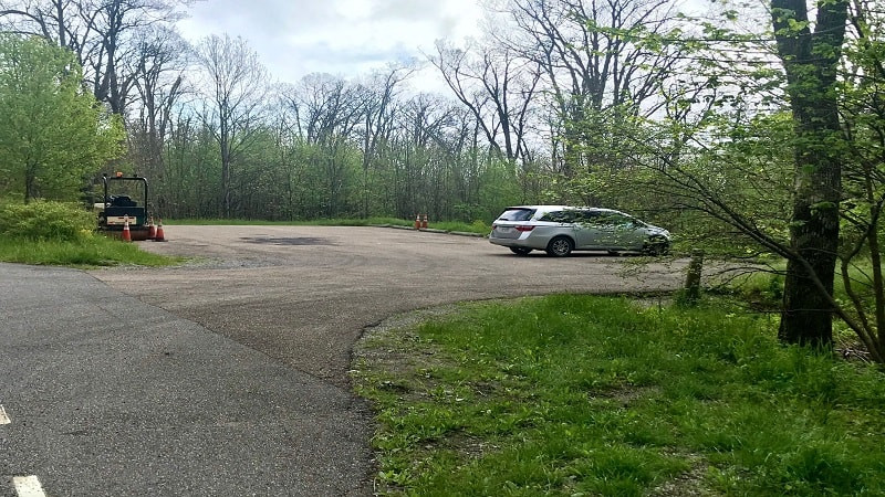
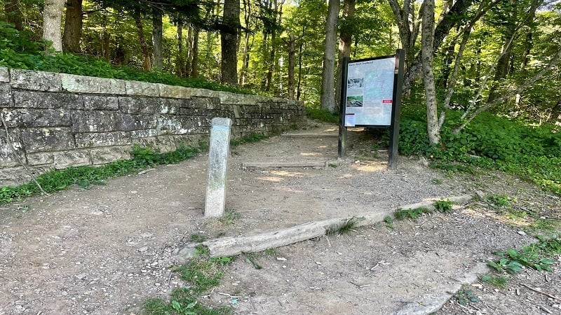
This 2.7-mile hike to Mary’s Rock begins at milepost 33.5 of Skyline Drive. Given its popularity, arriving early to secure a parking spot at the Meadow Spring parking area, located on the eastern side of Skyline Drive, is highly recommended, especially on weekends and during peak season.
The parking facility offers 12 spaces, comprising nine standard pull-in spots and three parallel parking spaces. Overflow parking is sometimes available along Skyline Drive itself, but exercise caution and park legally and safely.
 Meadow Spring Parking Area for Marys Rock Hike
The Meadow Spring parking area serves as a trailhead not only for Mary’s Rock hikers but also for those embarking on the Buck Hollow Trail (marked with blue blazes) and the Hazel Mountain Trail (marked with yellow blazes).
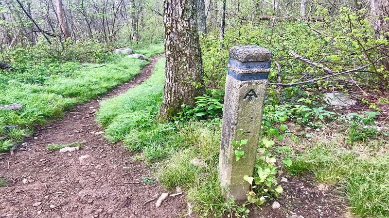
To commence your hike to Mary’s Rock, carefully cross Skyline Drive from the parking area. Look for a prominent concrete trail marker and follow the blue blazes, which will guide you on the Meadow Spring Trail towards your destination.
Meadow Spring Trail Ascent
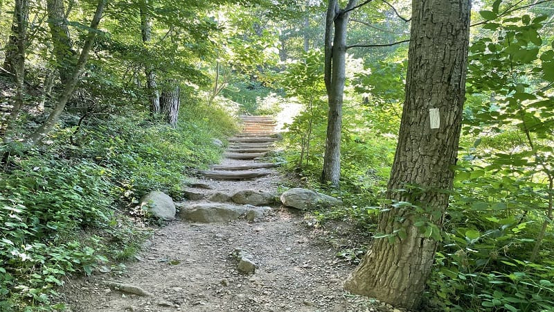
From the trailhead marker, the initial segment of the hike follows the Meadow Spring Trail. This blue-blazed path is a relatively short but moderately steep 0.6-mile climb that serves as a connector to the famed white-blazed Appalachian Trail.
To aid hikers in this initial ascent, particularly families with young children or those new to hiking, helpful wooden steps have been integrated into the trail in steeper sections, making the climb more manageable and less strenuous.
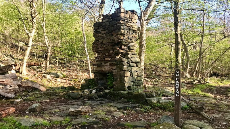
Approximately halfway along the shaded Meadow Spring Trail, a historical marker awaits – the intriguing stone chimney. This relic is all that remains of a former residence, a poignant reminder of the over 450 families who once lived within the boundaries of what is now Shenandoah National Park during the 1930s and 1940s, before the park’s establishment.
Junction with Appalachian Trail and Summit Push
At this point, you are also in close proximity to Meadow Spring itself, the natural spring for which the trail is named. Upon reaching the junction with the Appalachian Trail, merge onto the white-blazed path and continue for another 0.75 miles to reach the summit of Mary’s Rock.
Just before the final ascent to the summit, the Meadow Spring Trail merges with the northern approach trail. This junction consolidates hikers from both trailheads onto a final spur leading to Mary’s Rock summit.
 Historic Stone Chimney along Meadow Spring Trail to Marys Rock
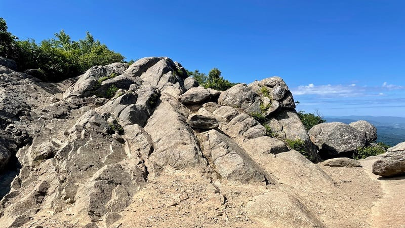
As you approach the summit, the dense tree cover gradually recedes, revealing increasingly expansive views. Prepare to be captivated by the spectacularly scenic panoramas that unfold – a hallmark of the most rewarding Skyline Drive hikes.
Upon reaching the summit area, you can admire the Shenandoah Valley from the main overlook point. For even more expansive and dramatic views, venture to climb atop the prominent Mary’s Rock itself. On my visit, I was fortunate to witness low clouds dramatically rolling through the valley below, enhancing the already stunning scene.
EXPLORE MORE: Discover the 10 Best Hikes in Shenandoah National Park for Unforgettable Views
For your return journey, simply retrace your steps back to the Meadow Spring parking area. Pay close attention at the junction where the spur trail meets the Appalachian Trail. After approximately 0.1 miles on the descent, the spur trail will end. Turn right at this junction to continue southbound on the Appalachian Trail and back towards Meadow Spring.
 Appalachian Trail Marker Near Marys Rock Summit in Shenandoah
Mary’s Rock Hike Option #2: The Northern Panorama Trail Approach
The second hiking option to Mary’s Rock, a 3.7-mile out-and-back trail, commences from the rear of the Panorama parking lot, located at milepost 31.6 on Skyline Drive. This trailhead is conveniently situated very close to the Thornton Gap entrance of Shenandoah National Park.
The Panorama parking area offers significantly more parking capacity compared to Meadow Spring, with at least 50 spaces available, along with the added convenience of public restrooms. A large trail kiosk is prominently positioned at the back of the parking lot, marking the trailhead for the northern approach to Mary’s Rock.
 Trail Kiosk at Panorama Parking for Marys Rock Hike Start
From the trail kiosk, follow a very short spur trail that quickly connects you to the white-blazed Appalachian Trail. Turn left onto the Appalachian Trail to begin your northward trek towards the summit of Mary’s Rock.
Very shortly after starting on the Appalachian Trail from Panorama, you will encounter a set of a dozen or so wooden steps built into the trail. These steps assist in the initial ascent, making it easier, especially for families with children or hikers preferring a gentler start.
 Early Wooden Steps on Appalachian Trail to Marys Rock from Panorama
As you proceed along the trail, you will notice scattered large rocks alongside the right side of the path. These rock formations offer fun opportunities for scrambling and exploring, appealing to both children and adults seeking a bit of playful adventure along the hike.
Approximately 1.0 mile into the hike from the Panorama trailhead, a notable opening on the left side of the trail presents itself. This natural break in the trees provides far-reaching mountain vistas and unique bird’s-eye perspectives of Skyline Drive winding through the landscape below.
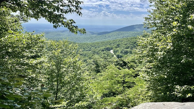 Skyline Drive Views from Appalachian Trail towards Marys Rock Hike
Continue hiking until you reach the 1.7-mile mark from Panorama. This point marks the junction where the northern approach trail merges with the southern approach trail (Meadow Spring Trail). Hikers from both starting points now converge onto a single blue-blazed spur trail that leads the final distance to Mary’s Rock summit.
Stay right at this junction to remain on the blue-blazed spur trail heading towards the summit. As you approach the top, similar to the southern approach, the trees thin out, and the panoramic views begin to unfold, culminating in truly awe-inspiring vistas.
Upon reaching the summit of Mary’s Rock via the northern approach, you are greeted with the same spectacular views as hikers arriving from the south. Take in the Shenandoah Valley panorama from the rocky overlook or ascend Mary’s Rock itself for even more expansive, far-reaching views.
The summit is an ideal location to pause, hydrate, and enjoy a snack while soaking in the scenery. Take your time to appreciate the views – there’s no need to rush. When you are ready to descend, simply retrace your steps back along the trail to the Panorama parking area.
Post-Hike Refreshments Near Mary’s Rock, VA
For hikers looking to refuel either within or near Shenandoah National Park after their Mary’s Rock adventure, Elkwallow Wayside, located at milepost 24.1 on Skyline Drive, is a convenient option (open seasonally).
Elkwallow Wayside offers a range of amenities including groceries, camping supplies, souvenirs, and quick grab-and-go food options like sandwiches. Restroom facilities and a picnic area are also available.
If you prefer dining options just outside the park boundaries, consider Sperryville Trading Market & Café. They offer takeout service, and you can also relax and dine on their welcoming front porch.
As you approach Sperryville, keep an eye out for one of Virginia’s iconic LOVEworks installations. You’ll find it on the right-hand side, providing a perfect photo opportunity to capture a memorable snapshot of your visit to the area.
To get a visual preview of the Mary’s Rock hiking experience before you go, take a look at this short video I created during one of my hikes to the summit.
Erin Gifford
Erin Gifford has explored over 300 trails in Virginia. She is also the author of three hiking guidebooks published by Falcon Guides. Need help finding the perfect Virginia hike? Utilize the Trail Finder feature or reach out to Erin via email at [email protected].