Snoopy Rock is one of Sedona’s most whimsical and recognizable rock formations, drawing visitors with its charming resemblance to the beloved cartoon beagle, Snoopy, lounging on his doghouse. Easily spotted from many vantage points in Uptown Sedona, this natural wonder offers not just a visual treat but also a moderately challenging and rewarding hike to its summit. This guide will walk you through the Snoopy Rock trail, ensuring you experience the best views and a memorable Sedona adventure.
Starting your trek from the Sombart Lane parking area, you’ll quickly immerse yourself in the beauty of the Munds Mountain Wilderness. The initial connector trail gently inclines uphill, leading you into the heart of Sedona’s stunning landscape. While Snoopy Rock isn’t visible from the trailhead itself, anticipation builds as you venture further.
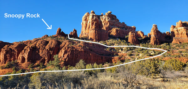 Snoopy Rock Sedona formation resembling the cartoon character Snoopy lying on his doghouse
Soon, you’ll arrive at the junction with the Marg’s Draw Trail, a key intersection on your path. While turning left would lead you towards Schnebly Hill Road and a right turn would take you to the Broken Arrow trailhead, your route to Snoopy Rock lies straight ahead. Follow the well-defined social trail that branches off, heading directly towards your destination.
As you proceed along the social trail, Snoopy Rock majestically comes into view on the left, perched at the edge of the cliffs. A network of trails weaves through this area, all converging towards a natural break in the cliffs. This break offers a gentler switchback ascent to the top of the formation. Staying on the most prominent trail will simplify your hike, making the uphill climb more manageable. Trust your instincts and route-finding skills to follow the easiest slope. You should find yourself on a clear social trail as you begin your upward journey.
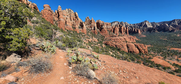 Well-trodden social trail leading hikers towards Snoopy Rock in Sedona, Arizona
As you gain elevation, prepare to be captivated by the increasingly dramatic views across Marg’s Pocket. Landmarks like Gibraltar Rock and Chicken Point become visible, painting a breathtaking panorama of the Sedona landscape. The ascent, while not overly strenuous, culminates in a slightly steeper final approach to Snoopy Rock. This last section requires a class 2 scramble, meaning you’ll need to use your hands for balance and support as you navigate the terrain.
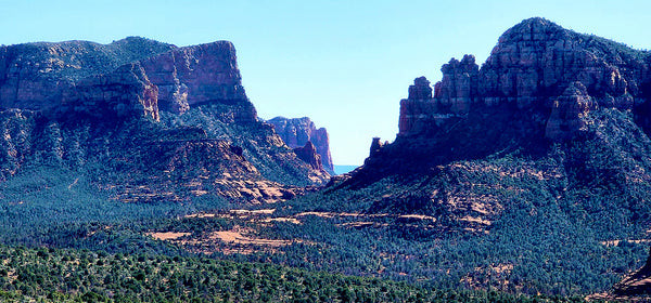 Scenic vista of Gibraltar Rock and Chicken Point from the Snoopy Rock hiking trail in Sedona
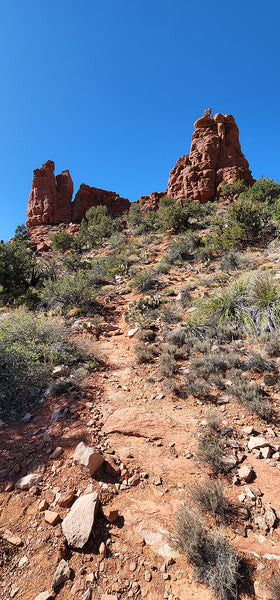 Final steep section of the Snoopy Rock trail requiring a class 2 scramble to reach the top
Reaching the top of Snoopy Rock is a truly rewarding experience. From this vantage point, you’ll be treated to stunning views of Uptown Sedona, the lush Oak Creek Canyon, and the imposing Thunder Mountain. This remarkable spot offers a similar grandeur to the summit of Cathedral Rock but with a fraction of the crowds. Take your time to relax, soak in the scenery, and enjoy the tranquility of having Snoopy Rock almost entirely to yourself.
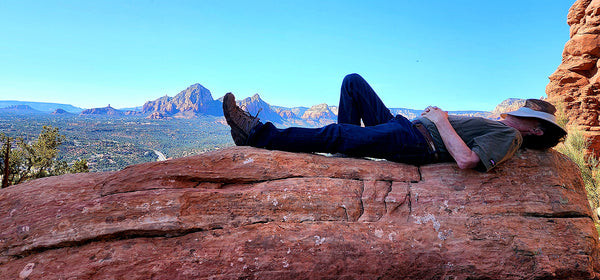 Solitude and panoramic views from the top of Snoopy Rock in Sedona, Arizona
FINDING THE TRAILHEADS
For the most direct route, parking at Sombart Lane is highly recommended. Choosing to park at Schnebly Hill Trailhead will add approximately 1.7 miles to your total roundtrip hike.
- Sombart Lane Trailhead: From the intersection of Routes 89A and 179 (the “Y” in Sedona), head south on 179 for 0.7 miles to Sombart Lane on your left. Follow Sombart Lane for 0.1 miles to the signed trailhead parking area on the left. Parking here is free and does not require a pass.
- Schnebly Hill Trailhead: From the “Y”, travel south on 179 for 0.3 miles. Turn left onto Schnebly Hill Road (the roundabout just beyond the Oak Creek Bridge) and continue for 0.8 miles. Turn left at the sign for Marg’s and Huckaby Trails. Trail signs begin near the kiosk. Follow the Marg’s Draw Trail heading south. Parking at this trailhead requires a Red Rock Pass or America the Beautiful Pass.
HIKE DETAILS
RATED: Easy to Moderate due to elevation gain
TOTAL DISTANCE:
- 2.2 miles roundtrip (Sombart Lane Trailhead)
- 3.9 miles roundtrip (Schnebly Hill Trailhead)
ELEVATION GAIN: 630 ft (Sombart Lane Trailhead)
ESTIMATED HIKING TIME: 2 hours roundtrip (Sombart Lane Trailhead)
BEST TIME TO GO: September to May. Start your hike early in the morning, especially during warmer months, to avoid the heat.
PET FRIENDLY: Yes, dogs are allowed on the trail, but the final scramble to Snoopy’s belly is not recommended for dogs due to its narrowness. Dogs must be kept on a leash. Please be responsible and clean up after your pet.