The formation of the Rocky Mountains’ rock is a complex geological story involving ancient seas, volcanic activity, and glacial erosion; Rockscapes.net explains this fascinating process. These majestic peaks owe their existence to a series of dramatic events spanning billions of years, resulting in the stunning rock formations we see today; explore the beauty of rock landscapes, find inspiration, and get expert advice at Rockscapes.net. Discover unique rock features, landscape design, and rock garden ideas.
1. What Were the Earliest Stages of Rocky Mountain Rock Formation?
The earliest stages of the Rocky Mountains rock formation date back 1.7 billion years to the Precambrian Era. During this time, metamorphic rocks like schist and gneiss were formed. Shortly after, around 1.6 billion years ago, a large volume of magma intruded into these older rocks, creating the Boulder Creek Batholith. This event caused regional metamorphism, forming the basement igneous and metamorphic rocks found throughout the region.
To elaborate, the Precambrian Era was a crucial period in Earth’s history, setting the stage for the geological structures we see today. The formation of metamorphic rocks involved intense heat and pressure, transforming existing rocks into new forms with different mineral compositions and textures. The intrusion of the Boulder Creek Batholith further altered the landscape, solidifying into granitic rock deep beneath the surface. This process laid the foundation for the future uplift and development of the Rocky Mountains. According to research from Arizona State University’s School of Earth and Space Exploration, the metamorphic processes during the Precambrian Era significantly contributed to the structural integrity of the continental crust in this region.
2. How Did Inland Seas Contribute to the Rocky Mountains’ Rock Layers?
Inland seas played a significant role in the formation of the Rocky Mountains rock layers during the Paleozoic Era (544-245 Ma). These seas covered much of present-day North America, depositing thick layers of marine sediments that eventually turned into sandstone and limestone.
These sedimentary layers are essential components of the Rocky Mountains’ geological composition. Over millions of years, the accumulation of marine sediments created substantial deposits that later lithified into solid rock. The sandstone and limestone formed from these sediments provide valuable insights into the ancient marine environments that once dominated the region. The study of these rock layers helps geologists reconstruct the environmental conditions and geological processes that shaped the area.
3. What Was the Significance of the Ancient Rocky Mountains?
The ancient Rocky Mountains, which rose about 285 million years ago, were a precursor to the modern range. This early mountain-building event raised the ancient Rockies, though they were much smaller, only reaching up to 2,000 feet high and stretching from Boulder to Steamboat Springs, Colorado.
While smaller than the modern Rockies, these ancient mountains played a crucial role in the region’s geological evolution. Over the next couple hundred million years, the ancient Rockies eroded away, leaving behind sediment and a much less rugged landscape. This erosion contributed to the formation of sedimentary basins and influenced the subsequent geological events that led to the uplift of the modern Rocky Mountains. The cycle of uplift and erosion is a common theme in mountain building, and the ancient Rockies exemplify this process.
4. How Did the Western Interior Seaway Impact Rock Formation in the Rockies?
About 100 million years ago, the Western Interior Seaway submerged the entire state of Colorado and much of middle North America. This flooding left behind large amounts of sedimentary deposits, such as the Pierre Shale and Fox Hills Formation (sandstone), significantly contributing to the rock composition of the Rocky Mountains.
The Western Interior Seaway was a vast inland sea that stretched from the Arctic Ocean to the Gulf of Mexico during the Cretaceous period. The sedimentary deposits from this seaway are widespread and represent a significant portion of the geological record in the Rocky Mountain region. The Pierre Shale, a dark-colored, fine-grained sedimentary rock, and the Fox Hills Formation, a sandstone deposit, are important stratigraphic units that provide valuable information about the environmental conditions and geological history of the area. These formations are often studied by geologists to understand the dynamics of ancient seaways and their impact on regional geology.
5. What Was the Laramide Orogeny, and How Did It Shape the Rockies?
The Laramide Orogeny, a mountain-building event that began 75 million years ago and continued through the Cenozoic era (65-2.6 Ma), uplifted the modern Rocky Mountains. This process was followed by extensive volcanism, ash falls, and mudflows, which left behind igneous rocks in areas like the Never Summer Range.
The Laramide Orogeny was a major tectonic event that profoundly shaped the landscape of western North America. Unlike typical mountain-building events that occur at plate boundaries, the Laramide Orogeny occurred far inland, driven by the shallow subduction of the Farallon Plate. This shallow subduction caused widespread uplift and deformation, resulting in the formation of the Rocky Mountains. The volcanism associated with this orogeny added layers of igneous rock to the geological mix, further diversifying the rock types found in the region. The Laramide Orogeny is a key event in understanding the formation and evolution of the Rocky Mountains.
6. How Did Uplift and Erosion Processes Contribute to the Rockies’ Current State?
Another period of uplift and erosion during the Tertiary period raised the Rockies to their present height and removed significant amounts of sedimentary deposits, revealing the much older basement rocks. These processes of uplift and erosion have been crucial in shaping the Rocky Mountains into their current form.
Uplift and erosion are fundamental geological processes that work in tandem to sculpt landscapes over time. Uplift raises the land surface, while erosion wears it down. In the case of the Rocky Mountains, repeated episodes of uplift have elevated the range, while erosion has removed vast quantities of sedimentary rock, exposing the underlying basement rocks. Glacial activity, in particular, has been a powerful erosional force, carving out valleys and shaping mountain peaks. The balance between uplift and erosion determines the overall form and structure of the Rocky Mountains.
7. What Role Did Glaciation Play in Sculpting the Rocky Mountains?
Glaciation, one of the strongest erosional forces on the planet, significantly shaped Rocky Mountain National Park as it appears today. Over the last 700,000 years, there have been at least six major glaciation events, with the two most recent (Bull Lake and Pinedale) causing the most easily noticeable alterations to the landscape.
Glaciers are massive bodies of ice and snow that form in areas where snow accumulation exceeds snowmelt. As glaciers move, they erode the underlying rock, carving out valleys and transporting sediment. The erosional power of glaciers is immense, capable of reshaping entire landscapes over time. In Rocky Mountain National Park, glaciers have carved out broad U-shaped valleys, leaving behind distinctive features such as moraines, cirques, and glacial striations. Glaciation has played a dominant role in shaping the rugged terrain and scenic beauty of the Rocky Mountains.
8. How Do Glaciers Erode and Shape the Landscape?
Glaciers erode and shape the landscape through a combination of processes. The massive ice blocks apply a formidable downward force on the rocks beneath them, enough to carve, crack, and push rocks of any size down the mountain (collectively known as till). Ripped-up rocks can be picked up and incorporated into the ice, scraping lines (striations) into the bedrock as the glaciers travel across the land and leaving behind evidence of the direction the glaciers dragged them along.
Glacial erosion is a complex process involving both abrasion and plucking. Abrasion occurs as the glacier scrapes and polishes the underlying rock with the sediment embedded in its ice. Plucking, also known as quarrying, involves the removal of large blocks of rock as the glacier freezes onto the bedrock and pulls it away. These erosional processes create distinctive features such as U-shaped valleys, cirques, and aretes. The sediment transported by glaciers is deposited in moraines, which are ridges or mounds of unsorted sediment that mark the former extent of the glacier. Glacial erosion is a powerful force that has significantly shaped the landscapes of many mountainous regions, including the Rocky Mountains.
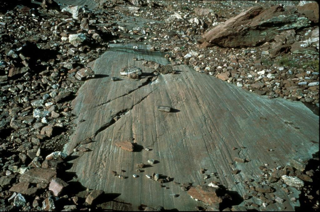 Glacial Striations, indicating the direction of glacial movement
9. What Are Moraines, and What Do They Indicate About Glaciers?
Moraines are depositional features found at the edges and end of glacial valleys. They are the dumping grounds of glaciers, composed of rocks of various sizes and glacial flour that were once trapped in the ice. Moraines indicate the size of the glacier and show how far the glacier flowed and how high in elevation it reached before the ice melted.
Moraines are important indicators of past glacial activity. Lateral moraines form along the sides of the glacier, while terminal moraines form at the end of the glacier. The composition and distribution of moraines provide valuable information about the size, extent, and dynamics of past glaciers. By studying moraines, geologists can reconstruct the history of glaciation in a particular region and gain insights into past climate conditions. Moraines are prominent features in many glaciated landscapes, including the Rocky Mountains.
10. What Types of Glaciers Were Present in Rocky Mountain National Park?
Scientists have grouped glaciers into three categories: cirque glaciers, valley glaciers, and continental ice sheets. Valley glaciers typically form at the top of a narrow (stream) valley and slowly spread downward. There are no more valley glaciers in Rocky Mountain National Park today, but they were abundant about 15,000 years ago. The only remaining type of glacier in Rocky Mountain National Park is a cirque glacier, which is a small glacier (sometimes the remnant of an old valley glacier) that occupies the bowl shape within a small valley.
Different types of glaciers have different characteristics and play different roles in shaping the landscape. Valley glaciers are long, narrow glaciers that flow down existing stream valleys. Cirque glaciers are smaller glaciers that occupy bowl-shaped depressions called cirques, typically located at the heads of valleys. Continental ice sheets are the largest type of glacier, covering vast areas of land. In Rocky Mountain National Park, valley glaciers were once abundant, carving out the U-shaped valleys that characterize the region. Today, only a few small cirque glaciers remain, remnants of the larger glaciers that once dominated the landscape.
11. Why Are the Rocky Mountains Considered Geologically “Weird?”
The modern-day Rocky Mountains are considered “weird” by geological standards because most mountain ranges occur at tectonically active spots where tectonic plates collide (convergent plate boundary), move away from each other (divergent plate boundary), or slide past each other (transform plate boundary). The Rockies, however, are located in the middle of a large, mostly inactive continental interior away from a plate boundary.
The location of the Rocky Mountains far from any active plate boundary is a geological puzzle. Most mountain ranges are formed by the collision of tectonic plates, as seen in the Himalayas or the Andes. The Rocky Mountains, however, are located in the interior of the North American plate, far from any plate boundary. This unusual location has led geologists to propose various theories to explain their formation, including the shallow subduction of the Farallon Plate and the presence of a hot spot beneath the region. The geological “weirdness” of the Rocky Mountains has made them a subject of ongoing research and debate.
12. How Did Plate Tectonics Contribute to the Formation of the Rockies?
At the beginning of the Laramide Orogeny roughly 70 Ma, a small tectonic plate made of more dense oceanic crust began to slide underneath the North American plate very shallowly. This shallow subduction angle meant that the Farallon Plate could have reached farther east under the continental interior before plunging deeper into the mantle, releasing water into the lithosphere above.
The shallow subduction of the Farallon Plate is believed to be a key factor in the formation of the Rocky Mountains. As the Farallon Plate subducted at a shallow angle, it exerted pressure on the overlying North American Plate, causing widespread uplift and deformation. The release of water from the subducting plate into the mantle lowered the melting point of rocks, leading to increased volcanic activity. This combination of uplift, deformation, and volcanism contributed to the formation of the Rocky Mountains far from any active plate boundary. The study of plate tectonics is essential for understanding the geological history of the Rocky Mountains.
13. What Role Did Volcanism Play in the Formation of the Rocky Mountains Rock?
Water lowers the melting point of rock, so this newly melted magma likely migrated upward into the lithosphere above the sinking Farallon Plate. This volcanism added layers of igneous rock to the geological composition of the Rocky Mountains.
Volcanism is an important process in mountain building, adding new rock material to the landscape and altering the composition of existing rocks. In the case of the Rocky Mountains, volcanism associated with the Laramide Orogeny contributed to the formation of igneous rocks such as granite and basalt. These volcanic rocks are found in various locations throughout the Rocky Mountains and provide valuable information about the magmatic processes that occurred during their formation. Volcanism has played a significant role in shaping the geological landscape of the Rocky Mountains.
14. How Did Erosion Expose the Core of the Rocky Mountains?
After burial from sedimentary rocks from the Western interior seaway and then the pyroclastic material from this volcanism the Rocky Mountains were essentially buried. Erosion from glaciers and rivers like the Arkansas and South Platte removed thousands of feet of this less robust sediment, leaving behind the hard basement granites and gneiss that makes up the core of the Rockies.
Erosion is a powerful force that can remove vast quantities of rock and sediment over time. In the case of the Rocky Mountains, erosion has played a crucial role in exposing the underlying basement rocks, which are composed of hard, resistant materials such as granite and gneiss. Glaciers and rivers have been particularly effective agents of erosion, carving out valleys and removing weaker sedimentary rocks. The process of erosion has shaped the Rocky Mountains into their current form, revealing the ancient core of the range.
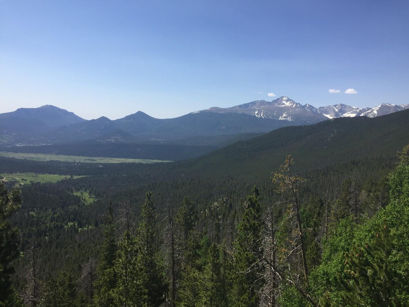 Rocky Mountain National Park, offering a majestic view of the landscape
15. What Explains the Stability and Height of the Rocky Mountains?
For mountains to be stable, there must be a crustal root underneath them that is thick enough to support the weight of the mountains. This mechanism is essentially the buoyancy of the lighter continental crust on top of the dense mantle underneath it. No definitive answer has proven exactly what is keeping the Rockies afloat yet, but it is believed to be a combination of very dense crust underneath the mountains (Pratt isostasy) and hot underlying mantle supporting the range’s weight.
The stability and height of mountain ranges are complex issues that involve the interplay of various geological processes. The concept of isostasy, which refers to the balance between the Earth’s crust and mantle, is often invoked to explain the stability of mountains. According to isostatic models, mountains are supported by a thick crustal root that extends deep into the mantle. The buoyancy of this crustal root helps to offset the weight of the mountains. However, the exact mechanisms that support the Rocky Mountains are still debated, and may involve a combination of factors, including crustal thickness, mantle density, and thermal support from the underlying mantle.
16. What Are Some of the Key Rock Types Found in the Rocky Mountains?
The Rocky Mountains are composed of a variety of rock types, reflecting their complex geological history. Some of the key rock types found in the Rockies include:
- Metamorphic Rocks: Schist and gneiss, formed during the Precambrian Era.
- Igneous Rocks: Granite and basalt, resulting from volcanic activity during the Laramide Orogeny.
- Sedimentary Rocks: Sandstone, limestone, and shale, deposited by ancient seas and rivers.
Each of these rock types tells a different part of the story of the Rocky Mountains, providing insights into the geological processes that have shaped the region over millions of years. The diversity of rock types in the Rockies makes them a fascinating area for geological study.
17. How Can the Study of Rock Formation Help Us Understand Earth’s History?
The study of rock formation is essential for understanding Earth’s history. Rocks provide a record of past geological events, environmental conditions, and biological activity. By studying the composition, structure, and age of rocks, geologists can reconstruct the sequence of events that have shaped our planet over billions of years.
The formation of the Rocky Mountains is just one example of how the study of rocks can shed light on Earth’s history. By examining the different rock types found in the Rockies, geologists can piece together the story of how these mountains formed, from the ancient seas that deposited sediments to the volcanic eruptions that added igneous rocks. The study of rock formation is a key tool for understanding the dynamic processes that have shaped our planet and continue to do so today.
18. What Are the Implications of Rocky Mountain Geology for Landscaping and Construction?
The geology of the Rocky Mountains has significant implications for landscaping and construction in the region. The types of rocks found in an area can influence soil composition, drainage patterns, and the stability of slopes. Understanding the geological characteristics of a site is essential for designing landscapes and constructing buildings that are both aesthetically pleasing and environmentally sound.
For example, areas with abundant sedimentary rocks may have soils that are prone to erosion, requiring special measures to stabilize slopes and prevent landslides. Areas with volcanic rocks may have soils that are rich in nutrients, making them ideal for gardening and landscaping. The geological characteristics of a site can also influence the types of plants that will thrive in the area. By understanding the geology of the Rocky Mountains, landscapers and builders can create sustainable and harmonious designs that complement the natural environment.
19. How Can I Incorporate Rocky Mountain Rock into My Landscape Design?
Incorporating Rocky Mountain rock into your landscape design can add a touch of natural beauty and regional character to your outdoor spaces. Whether you’re creating a rock garden, building a retaining wall, or simply adding decorative boulders, Rocky Mountain rock can enhance the aesthetic appeal of your landscape.
Some popular ways to incorporate Rocky Mountain rock into your landscape design include:
- Rock Gardens: Create a stunning rock garden featuring a variety of native plants and rock types.
- Retaining Walls: Build a sturdy and attractive retaining wall using natural stone from the Rocky Mountains.
- Pathways and Walkways: Design pathways and walkways using flagstone or gravel made from crushed rock.
- Decorative Boulders: Add large boulders as focal points in your landscape, creating a sense of scale and drama.
- Water Features: Incorporate rocks into water features such as waterfalls, ponds, and streams, creating a natural and tranquil atmosphere.
When selecting rock for your landscape design, consider the color, texture, and size of the stones, as well as their compatibility with the surrounding environment. Visit Rockscapes.net for a wide selection of Rocky Mountain rock and expert advice on incorporating it into your landscape design.
20. What Resources Are Available for Learning More About Rocky Mountain Geology?
There are many resources available for learning more about Rocky Mountain geology, including books, websites, museums, and educational programs. Some recommended resources include:
- Books: “Roadside Geology of Colorado” by Felicie Williams and Halka Chronic
- Websites: The United States Geological Survey (USGS) website (usgs.gov)
- Museums: The Denver Museum of Nature & Science (dmns.org)
- Educational Programs: Geology courses offered at local colleges and universities
By exploring these resources, you can deepen your understanding of Rocky Mountain geology and gain a greater appreciation for the natural beauty of this remarkable region.
21. How Does Weathering and Erosion Affect Rocky Mountain Rock Over Time?
Weathering and erosion continually reshape the rocks of the Rocky Mountains. Weathering breaks down rocks into smaller pieces through physical and chemical processes, while erosion transports these fragments away. Over time, these forces can significantly alter the appearance and structure of rock formations.
Types of Weathering:
- Physical Weathering: Includes freeze-thaw cycles, where water expands in cracks, breaking rocks apart.
- Chemical Weathering: Involves chemical reactions that alter the rock’s composition, such as oxidation and dissolution.
Agents of Erosion:
- Water: Rivers and streams carve valleys and transport sediments.
- Wind: Carries fine particles, eroding exposed surfaces.
- Ice: Glaciers grind and scour the landscape, leaving behind distinctive features.
Understanding these processes helps us appreciate the dynamic nature of the Rocky Mountains and the forces that continue to shape them.
22. What Unique Geological Features Can Be Found in the Rocky Mountains?
The Rocky Mountains are home to numerous unique geological features, reflecting their complex history.
Examples of Unique Features:
- U-Shaped Valleys: Carved by glaciers, these valleys have broad, flat bottoms and steep sides.
- Cirques: Bowl-shaped depressions at the heads of glacial valleys.
- Moraines: Ridges of sediment deposited by glaciers, marking their former extent.
- Glacial Striations: Scratches on bedrock caused by glaciers, indicating the direction of ice movement.
- Hanging Valleys: Tributary valleys that enter the main valley high above the valley floor, often with waterfalls.
These features provide evidence of past glacial activity and tectonic forces, making the Rocky Mountains a fascinating place to explore for geologists and nature enthusiasts alike.
23. Can You Recommend Any Scenic Drives in the Rocky Mountains That Showcase Rock Formations?
Yes, several scenic drives in the Rocky Mountains offer stunning views of rock formations.
Recommended Scenic Drives:
- Trail Ridge Road (Colorado): The highest continuous paved road in North America, offering panoramic views of the Rocky Mountains and their geological features.
- Million Dollar Highway (Colorado): A thrilling drive through steep canyons and past rugged peaks.
- Going-to-the-Sun Road (Montana): A breathtaking route through Glacier National Park, showcasing glaciers and glacial landforms.
- Beartooth Highway (Wyoming and Montana): A winding road through alpine meadows and past towering mountains.
These drives provide opportunities to witness the grandeur of the Rocky Mountains and appreciate their geological diversity. Remember to check road conditions and seasonal closures before planning your trip.
24. How Do the Rocky Mountains Compare to Other Mountain Ranges in Terms of Formation?
The Rocky Mountains differ from many other mountain ranges in terms of their formation. Unlike the Himalayas, which formed from the collision of tectonic plates, the Rockies formed far from any active plate boundary. This makes their formation somewhat unique.
Comparison Points:
- Himalayas: Formed by the collision of the Indian and Eurasian plates.
- Andes: Formed by the subduction of the Nazca plate beneath the South American plate.
- Alps: Formed by the collision of the African and Eurasian plates.
The Rocky Mountains’ formation, primarily through the Laramide Orogeny and shallow subduction, sets them apart from these other ranges, making them a subject of ongoing geological research.
25. What Types of Wildlife Are Commonly Found in Rocky Mountain Rock Habitats?
Rocky Mountain rock habitats support a variety of wildlife adapted to the rugged terrain and harsh conditions.
Common Wildlife Species:
- Bighorn Sheep: Known for their ability to navigate steep, rocky slopes.
- Mountain Goats: Agile climbers that inhabit high-altitude rock areas.
- Pikas: Small, rodent-like creatures that live in rock piles and alpine meadows.
- Marmots: Large ground squirrels that burrow in rocky areas.
- Birds of Prey: Eagles, hawks, and falcons that nest on cliffs and hunt in open areas.
These species play important roles in the ecosystem, contributing to the biodiversity and ecological balance of the Rocky Mountains.
26. What Are Some of the Challenges of Building Structures in Rocky Mountain Terrain?
Building structures in Rocky Mountain terrain presents several challenges due to the steep slopes, unstable soils, and harsh weather conditions.
Construction Challenges:
- Slope Stability: Ensuring that structures are built on stable slopes to prevent landslides.
- Soil Erosion: Controlling erosion to protect water quality and prevent damage to infrastructure.
- Accessibility: Overcoming logistical challenges of transporting materials to remote construction sites.
- Weather Conditions: Dealing with extreme temperatures, heavy snowfalls, and high winds.
- Environmental Regulations: Complying with regulations to protect sensitive ecosystems.
Addressing these challenges requires careful planning, innovative engineering solutions, and a commitment to sustainable construction practices.
27. How Does Rock Type Affect the Vegetation That Grows in the Rocky Mountains?
Rock type significantly influences the vegetation that grows in the Rocky Mountains. Different rock types weather into soils with varying nutrient content, drainage characteristics, and pH levels, which in turn affect plant growth.
Examples of Rock-Vegetation Relationships:
- Limestone: Often supports alkaline-loving plants.
- Granite: Typically forms acidic soils.
- Shale: Can create poorly drained soils.
Understanding these relationships helps ecologists predict the distribution of plant communities and manage ecosystems effectively.
28. What Safety Precautions Should Be Taken When Hiking in Rocky Mountain Rock Areas?
Hiking in Rocky Mountain rock areas requires awareness of potential hazards and adherence to safety precautions.
Safety Tips:
- Wear Appropriate Footwear: Sturdy hiking boots with good ankle support are essential.
- Stay on Marked Trails: Avoid venturing off-trail, where the terrain can be unstable.
- Be Aware of Weather Conditions: Check the forecast before heading out and be prepared for sudden changes.
- Carry Plenty of Water and Snacks: Stay hydrated and maintain energy levels.
- Inform Someone of Your Plans: Let someone know where you’re going and when you expect to return.
- Watch for Wildlife: Be aware of animals and give them plenty of space.
- Be Cautious on Steep Slopes: Avoid loose rocks and unstable areas.
By following these guidelines, you can enjoy a safe and rewarding hiking experience in the Rocky Mountains.
29. What Impact Does Mining Have on Rocky Mountain Rock Formations?
Mining can have significant impacts on Rocky Mountain rock formations, altering landscapes and ecosystems.
Potential Impacts:
- Habitat Destruction: Mining operations can destroy or degrade wildlife habitats.
- Water Pollution: Mining can release pollutants into streams and groundwater.
- Soil Erosion: Disturbed soils can erode, leading to sedimentation of waterways.
- Visual Impacts: Mining can create unsightly scars on the landscape.
Responsible mining practices and reclamation efforts are essential to minimize these impacts and restore affected areas.
30. What Future Geological Events Might Affect the Rocky Mountains?
While the Rocky Mountains are currently located in a relatively stable tectonic setting, future geological events could still affect them.
Potential Future Events:
- Continued Erosion: Weathering and erosion will continue to shape the landscape over time.
- Seismic Activity: Earthquakes, though less frequent than in active plate boundary zones, can still occur.
- Climate Change: Changes in temperature and precipitation patterns could alter vegetation and accelerate erosion rates.
Understanding these potential future events helps us plan for and mitigate their potential impacts on the Rocky Mountains and the communities that depend on them.
Discover the beauty and resilience of the Rocky Mountains’ rock formations; visit rockscapes.net for inspiration, expert advice, and the finest selection of natural stones to enhance your landscape. Transform your outdoor spaces with the enduring charm of the Rockies! Address: 1151 S Forest Ave, Tempe, AZ 85281, United States. Phone: +1 (480) 965-9011.
FAQ Section
Q1: How old are the oldest rocks in the Rocky Mountains?
The oldest rocks in the Rocky Mountains date back approximately 1.7 billion years to the Precambrian Era.
Q2: What is the Laramide Orogeny?
The Laramide Orogeny was a major mountain-building event that uplifted the modern Rocky Mountains, beginning about 75 million years ago.
Q3: How did glaciers shape the Rocky Mountains?
Glaciers carved out U-shaped valleys, cirques, and left behind moraines and glacial striations, significantly shaping the landscape.
Q4: Why are the Rocky Mountains considered geologically “weird”?
The Rockies are located in the middle of a continental interior, away from any active plate boundary, which is unusual for mountain ranges.
Q5: What role did the Western Interior Seaway play in the Rockies’ formation?
The seaway deposited large amounts of sedimentary rocks, such as the Pierre Shale and Fox Hills Formation.
Q6: What are moraines?
Moraines are depositional features composed of rocks and glacial flour, indicating the size and extent of past glaciers.
Q7: What is the primary type of erosion that affects the Rocky Mountains today?
The primary type of erosion affecting the Rocky Mountains today is glacial erosion.
Q8: What is the significance of glacial striations?
Glacial striations are scratches on bedrock that indicate the direction of ice movement, providing evidence of past glacial activity.
Q9: How does uplift and erosion contribute to the current state of the Rockies?
Uplift raises the mountains, while erosion removes sedimentary deposits, revealing the older basement rocks.
Q10: What is the role of plate tectonics in the formation of the Rocky Mountains?
The shallow subduction of the Farallon Plate played a key role, causing widespread uplift and deformation.