Potato Chip Rock, a unique rock formation near San Diego, is a must-see for hikers and photographers. Rockscapes.net offers detailed guides to help you explore this iconic landmark and other stunning rock formations. Ready to plan your adventure? Let’s find out how far you’ll hike and how to get there.
1. What is Potato Chip Rock and Where Can You Find It?
Potato Chip Rock is a thin, potato chip-shaped rock formation located on the summit of Mount Woodson in Poway, California, about 30 minutes north of San Diego. This unique rock formation attracts hikers and photographers looking for the perfect photo opportunity. The rock’s precarious appearance makes for a thrilling photo backdrop, giving the illusion that you’re about to fall off a cliff.
1.1. How Was Potato Chip Rock Formed?
Potato Chip Rock’s formation is a result of spheroidal weathering, a process where the edges and corners of rocks are chemically weathered more rapidly than their flat surfaces. According to research from Arizona State University’s School of Earth and Space Exploration, this type of weathering is common in granitic rock formations like those found on Mount Woodson. Over thousands of years, this process has sculpted the rock into its current fragile-looking shape.
1.2. Where Exactly is Potato Chip Rock Located?
Potato Chip Rock sits near the summit of Mount Woodson, within the larger Cleveland National Forest. The most popular trail to reach it begins at Lake Poway.
The address for the Lake Poway trailhead is: 14644 Lake Poway Rd, Poway, CA 92064.
Using this address in your GPS will take you to the most scenic and well-equipped route to Potato Chip Rock. Be cautious when searching for “Mt Woodson Trailhead” or “Potato Chip Rock Trailhead,” as these may lead you to alternative, less desirable routes.
1.3. How Do I Get to Potato Chip Rock?
There are several routes to hike to Potato Chip Rock, each with its own unique characteristics:
- Lake Poway Trail: This is the most popular and scenic route. It offers facilities like bathrooms and picnic areas, and the trail is well-maintained. However, there is a non-resident fee on weekends and holidays.
- Mt Woodson Road Trail: A shorter, steeper, and paved route that starts on the side of Rt. 67. This route is free but lacks the scenery of the Lake Poway Trail.
- Fry-Koegel Trail: This trail is not paved but offers great scenery, although not as good as the Lake Poway route. There are no bathrooms available on this route.
2. How Many Miles Is the Hike to Potato Chip Rock?
The most common route, starting from Lake Poway, is approximately 7.5 to 8 miles round trip. This route provides a moderate to strenuous hike, gaining around 2,100 feet in elevation.
2.1. How Long Does It Take to Hike to Potato Chip Rock?
The hike to Potato Chip Rock via the Lake Poway route typically takes 3 to 5 hours to complete, depending on your fitness level and how long you spend at the summit.
2.2. What is the Elevation Gain of the Hike?
The elevation gain for the Potato Chip Rock hike from Lake Poway is approximately 2,100 feet (640 meters).
2.3. Lake Poway Route Details
Starting from Lake Poway, the trail gradually ascends through scenic landscapes, offering views of the lake and surrounding mountains. The final stretch to Potato Chip Rock involves a steeper climb.
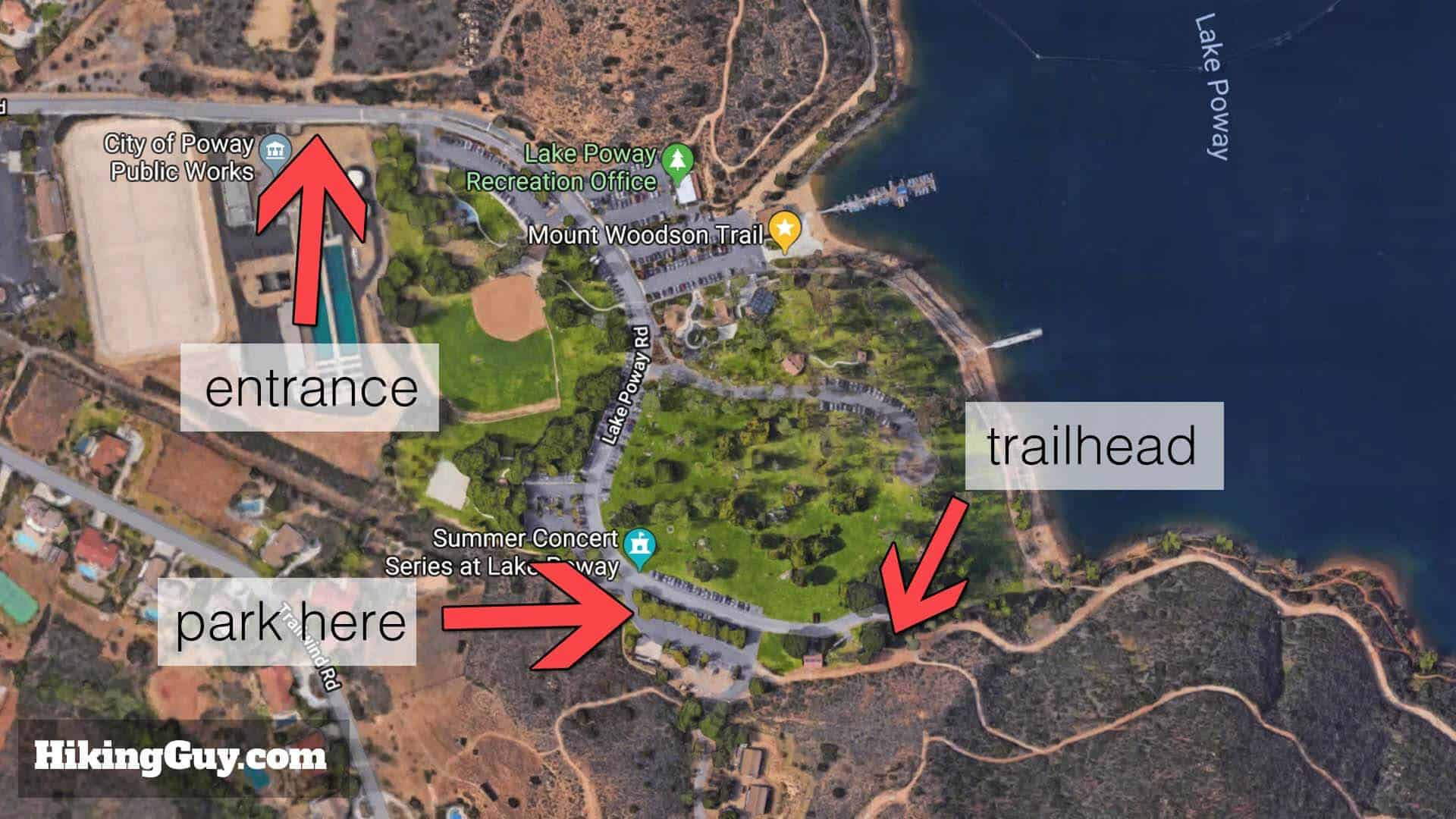 map layout of potato chip rock trailhead
Alt text: Detailed map of Potato Chip Rock trailhead at Lake Poway, Poway, CA, showcasing various hiking routes and points of interest.
2.4. Mt Woodson Road Route Details
The Mt Woodson Road route is a steeper, paved option. While shorter, it can be more challenging due to the constant incline.
2.5. Fry-Koegel Trail Route Details
The Fry-Koegel Trail provides a more natural hiking experience but is less maintained and lacks facilities.
3. Planning Your Hike to Potato Chip Rock
Before embarking on your hike, it’s crucial to plan ahead to ensure a safe and enjoyable experience.
3.1. What Should I Bring on the Hike?
- Water: Bring at least 1 liter of water; 3 liters is recommended, especially on hot days.
- Snacks: High-energy snacks to keep you fueled during the hike.
- Sun Protection: Hat, sunglasses, and sunscreen are essential, as there is minimal shade on the trail.
- Proper Footwear: Sturdy hiking shoes with good traction.
- Camera: To capture the iconic photo on Potato Chip Rock.
- First Aid Kit: For minor injuries.
3.2. What is the Best Time of Year to Hike to Potato Chip Rock?
The best time to hike to Potato Chip Rock is during the spring and fall when the weather is mild. Avoid hiking during the summer months due to extreme heat.
3.3. Are There Any Fees or Permits Required?
There is a non-resident fee to enter Lake Poway on weekends and holidays. Poway residents with ID can enter for free. Check the Lake Poway website for current fee information and hours of operation.
3.4. Is Potato Chip Rock Kid-Friendly?
The hike to Potato Chip Rock is challenging and may not be suitable for young children. Assess your children’s hiking abilities and endurance before attempting this hike.
4. Step-by-Step Hiking Directions from Lake Poway
Here are detailed directions to guide you from the Lake Poway parking lot to Potato Chip Rock:
- Parking and Trailhead: Park in the far lot of Lake Poway. The trailhead is located near the bathrooms and water fountains.
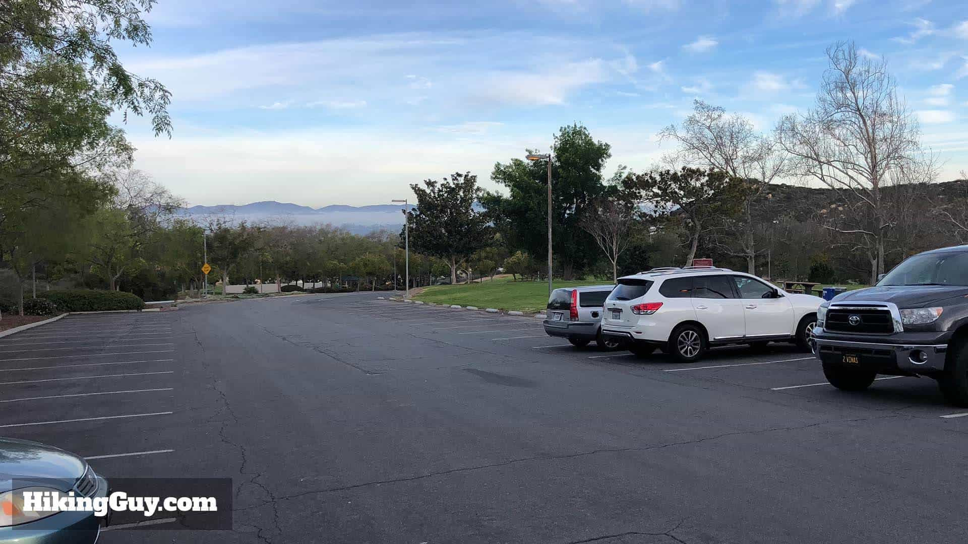 parking lot in poway
Alt text: Expansive parking area at Lake Poway, the starting point for the popular hike to Potato Chip Rock, Poway, California.
- Sumac Trail: Head around the bathroom building to the right and cross the grass to the trail. Bear right onto the Sumac Trail (though it may not be marked).
- Above the Lake: Continue left above the lake, avoiding the trail that joins from the right.
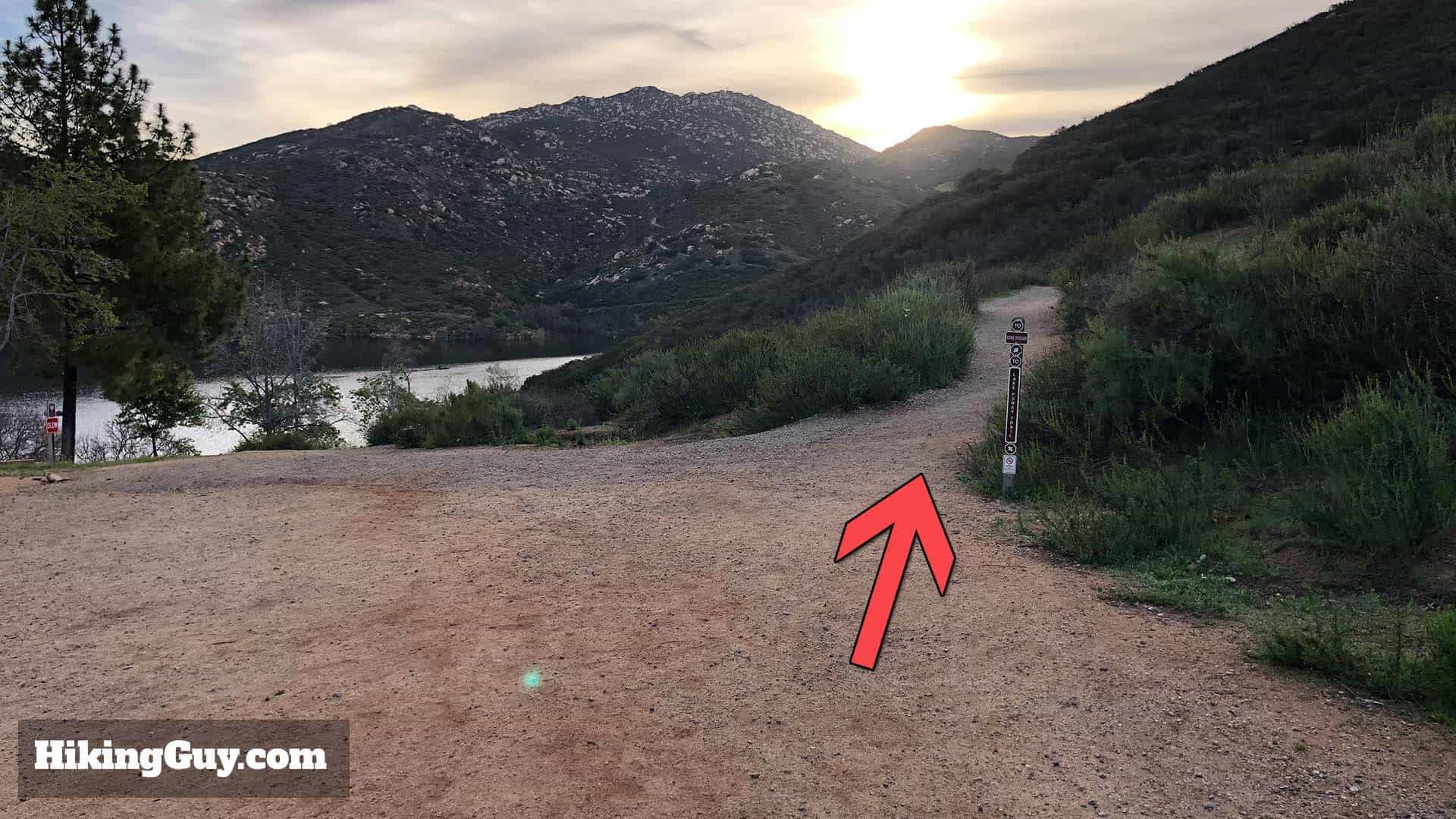 trail in poway
Alt text: Scenic trail winding through lush greenery near Lake Poway, marking the beginning of the hike to Potato Chip Rock.
- Junction: At the junction, continue straight towards Potato Chip Rock and Mt Woodson. The left trail leads to the lake.
- Mt Woodson Trail: Avoid the trail joining from the right and continue hiking left, around Lake Poway.
- Important Junction: You’ll see porta-potties, which is your last bathroom opportunity. To the right of the bathrooms is the Mt Woodson Trail. Make a right at the board.
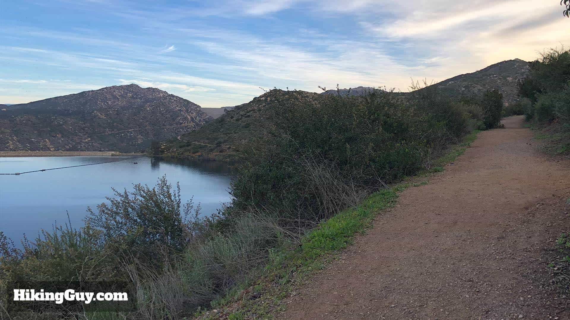 lake poway
Alt text: Serene view of Lake Poway from the hiking trail, capturing the natural beauty along the path to Potato Chip Rock.
- Hiking Board: Check the hiking board for trail information and warnings.
- Mt Woodson Trail Sign: Follow the sign marking the start of the Mt Woodson Trail.
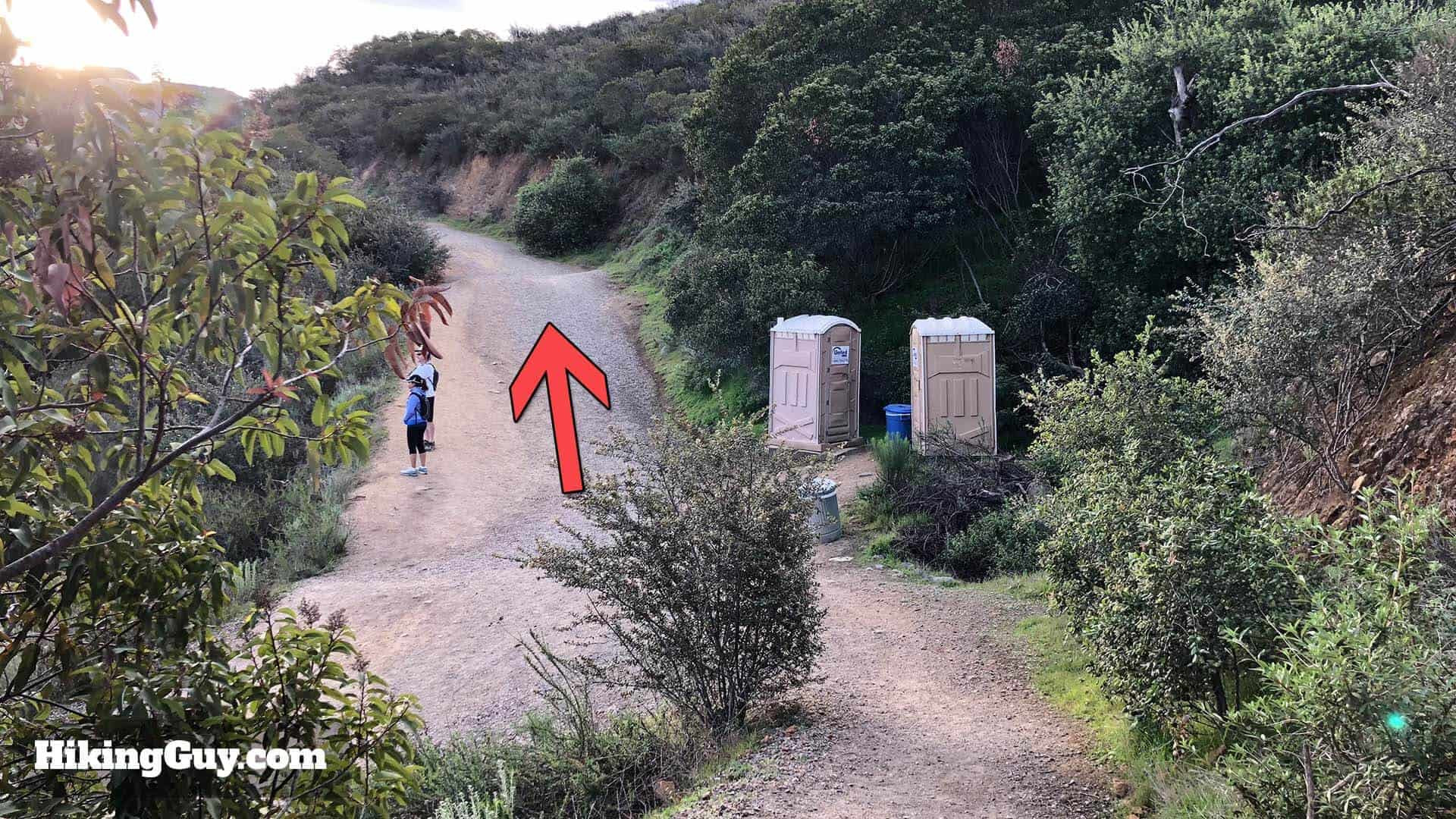 porta potties on trail
Alt text: Porta-potties along the Potato Chip Rock trail, marking a key junction and last restroom opportunity before continuing the hike.
- Ascent: The trail begins to ascend. It gets steep, but manageable.
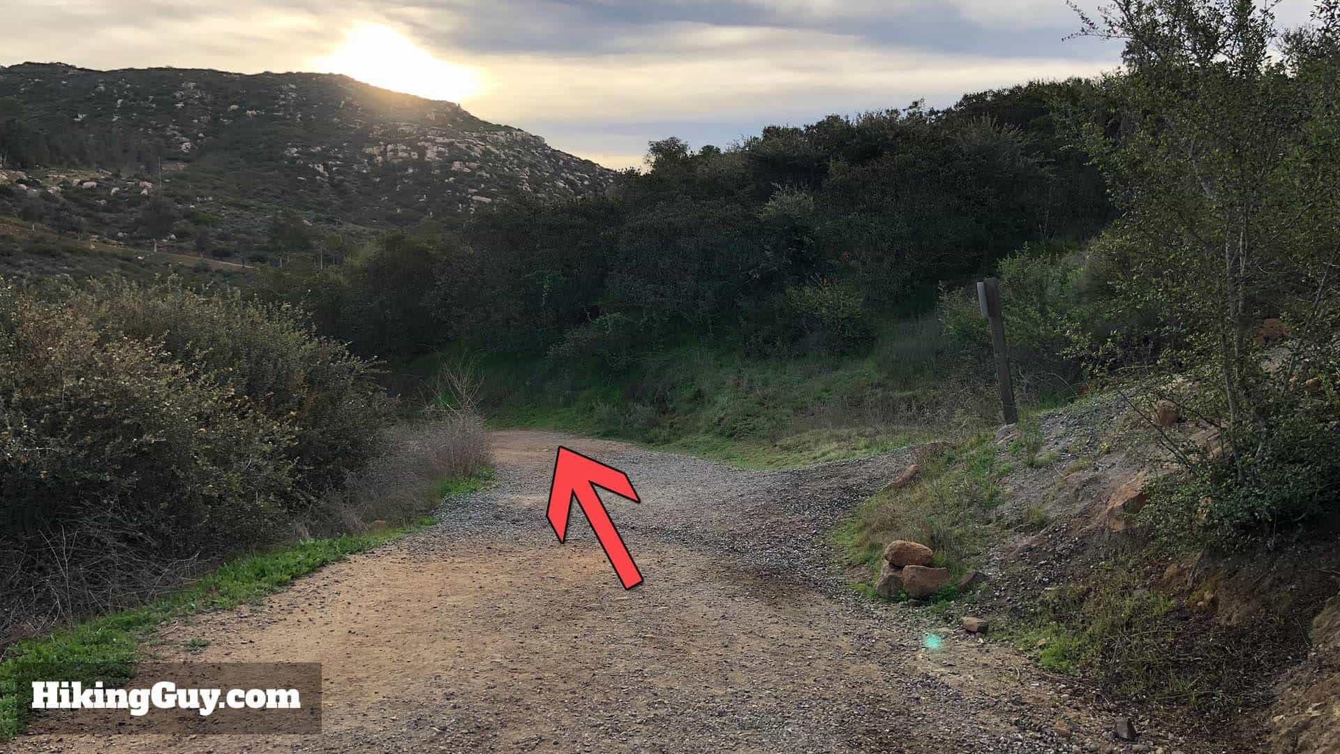 Potato Chip Rock trail
Alt text: The picturesque Potato Chip Rock trail winding through the landscape, guiding hikers toward their destination.
- Stay Straight: Stay on the Mt Woodson Trail until you reach Potato Chip Rock.
- Avoid Side Trail: Stay left on the main trail, avoiding the side trail to the right.
- Scenic Overlook: Reach a wide area with a bench offering views of Lake Poway and the surrounding mountains.
 trail
trail
Alt text: A well-maintained trail segment with clear signage, ensuring hikers stay on the correct path towards Potato Chip Rock.
- Warren Canyon Trail Junction: Hike to the left towards Mt Woodson.
- Boulder Field: The trail makes its way up through a boulder field formed by spheroidal weathering.
- Ridge: After the boulder field, you’ll reach a ridge. Keep right.
- Another Split: You’ll have another split, stay right again.
- Pole Marker: You’ll see a pole marker confirming that you’re on the Mt Woodson Trail.
- Relatively Level Section: This section is relatively level and offers views to the east and west.
- Radio Towers: You’ll start to see the radio towers on top of Mt Woodson in the distance.
- Potato Chip Rock: You’ll know you’re at Potato Chip Rock when you see the crowd.
- Mt Woodson Summit: Continue hiking for a minute up the trail past Potato Chip Rock to visit the summit of Mt Woodson.
5. Staying Safe on the Trail
Safety should be your top priority when hiking to Potato Chip Rock.
5.1. What Are the Potential Hazards?
- Heat: The trail offers little to no shade and can get extremely hot, especially during summer.
- Falls: The rocks can be slippery, and a fall from Potato Chip Rock can result in serious injury.
- Wildlife: Be aware of local wildlife, such as snakes and mountain lions.
- Crowds: The trail can get crowded, especially on weekends, increasing the risk of accidents.
5.2. How Can I Avoid These Hazards?
- Start Early: Begin your hike early in the morning to avoid the heat.
- Stay Hydrated: Drink plenty of water throughout the hike.
- Wear Appropriate Clothing: Wear lightweight, breathable clothing and sturdy hiking shoes.
- Be Cautious on the Rocks: Avoid risky poses on Potato Chip Rock and be mindful of other hikers.
- Stay on the Trail: Stick to marked trails to avoid getting lost and minimize your impact on the environment.
5.3. Is Potato Chip Rock Dangerous?
Potato Chip Rock is generally safe if you exercise caution. Avoid risky behavior such as hanging off the rock or attempting dangerous poses. The drop from the rock is about 40 feet.
6. Alternative Hiking Routes to Potato Chip Rock
While the Lake Poway route is the most popular, there are alternative trails to reach Potato Chip Rock.
6.1. Mt Woodson Trail from Highway 67
This 6.4-mile out-and-back trail near Poway, California, is generally considered challenging. It takes an average of 2 hours and 53 minutes to complete. This is a very popular area for hiking, so you’ll likely encounter other people while exploring. The trail is open year-round and is beautiful to visit anytime. You’ll need to leave pups at home — dogs aren’t allowed on this trail.
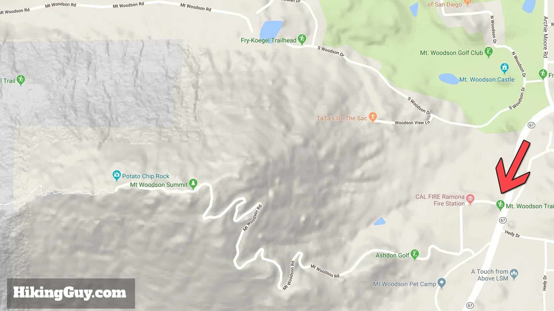 mt woodson short hike map
Alt text: Hiking map of Mt Woodson short hike starting on Rt. 67, showing the paved path to Potato Chip Rock and the summit.
6.2. Fry-Koegel Trail
The Fry-Koegel Trail is less crowded and offers a more rugged hiking experience.
7. Experiencing the Beauty of Mount Woodson
Beyond Potato Chip Rock, Mount Woodson offers stunning views and unique geological features.
7.1. What is Spheroidal Weathering?
Spheroidal weathering is a form of chemical weathering that affects jointed bedrock and results in the formation of concentric or spherical layers of highly weathered rock. This process is responsible for the rounded boulder formations seen on Mount Woodson.
7.2. Interesting Facts About Mt Woodson
Mount Woodson has a rich history and unique characteristics.
7.3. What is the History of Mt Woodson?
Originally known as “Mountain of Moonlit Rocks” by local Native Americans, Mt Woodson was renamed in 1895 after a settler who moved to the area.
7.4. What Kind of Wildlife Can Be Seen on the Trail?
Hikers may encounter a variety of wildlife, including birds, lizards, snakes, and occasionally, larger animals like coyotes and deer.
8. How to Capture the Perfect Photo at Potato Chip Rock
Taking a memorable photo at Potato Chip Rock requires some planning and patience.
8.1. Best Times for Photography
The best time to photograph Potato Chip Rock is during the early morning or late afternoon when the lighting is soft and golden.
8.2. Posing Ideas
- Sitting on the Edge: The classic pose is sitting on the edge of the rock, looking out at the view.
- Standing with Arms Out: Another popular pose is standing with your arms outstretched, as if you’re about to take flight.
- Crouching for Perspective: Crouch down to create the illusion that the drop is more dramatic than it actually is.
 people on Potato Chip Rock
Alt text: A group of hikers gathered at Potato Chip Rock, awaiting their turn to capture the iconic photo on the unique rock formation.
8.3. Tips for Taking Photos
- Use a Wide-Angle Lens: A wide-angle lens will capture more of the surrounding landscape.
- Check Your Settings: Make sure your camera settings are appropriate for the lighting conditions.
- Be Patient: There may be a line to take photos, so be patient and wait your turn.
- Respect Others: Be mindful of other hikers and avoid blocking their views.
9. Essential Gear Recommendations for Hiking Potato Chip Rock
Having the right gear can significantly enhance your hiking experience. Here are some top recommendations:
9.1. Backpack
- Osprey Hikelite 26: A lightweight and durable daypack with a trampoline mesh to keep your back dry.
9.2. Hiking Shoes
- Topo MTN Racer 4: These shoes offer a wide toe box to prevent blisters and provide excellent grip and cushioning.
9.3. Satellite Communicator
- Garmin inReach Mini 2: For reliable SOS coverage in remote areas.
9.4. Navigation Tools
- AllTrails+: Provides up-to-date trip reports, offline maps, and off-trail alerts.
- Garmin Fenix 8: A multisport watch for maps, tracking, and routing.
10. Frequently Asked Questions (FAQ) About Potato Chip Rock
Here are some common questions about hiking to Potato Chip Rock:
10.1. How Crowded Does Potato Chip Rock Get?
Potato Chip Rock can get very crowded, especially on weekends and holidays. Arriving early in the morning is the best way to avoid the crowds.
10.2. Is There Cell Service on the Trail?
Cell service can be spotty on the trail. Don’t rely on your phone for navigation.
10.3. Can I Bring My Dog on the Hike?
Dogs are not allowed on the Mt Woodson Trail from Highway 67. Check local regulations for the Lake Poway and Fry-Koegel trails.
10.4. Are There Bathrooms on the Trail?
Bathrooms are available at the Lake Poway trailhead and porta-potties are located at the junction of the Mt Woodson Trail. There are no bathrooms on the Mt Woodson Road or Fry-Koegel trails.
10.5. What Should I Do If I Encounter a Snake?
If you encounter a snake, give it plenty of space and avoid approaching or harassing it.
10.6. Can I Hike to Potato Chip Rock at Night?
Hiking at night is generally not recommended due to safety concerns.
10.7. What is the Weather Like on Mt Woodson?
The weather on Mt Woodson can vary. Check the forecast before you go and be prepared for changing conditions.
10.8. Are There Any Water Fountains on the Trail?
Water fountains are available at the Lake Poway trailhead.
10.9. What is the Best Way to Avoid Getting Lost?
Stay on marked trails and carry a map and compass or a GPS device.
10.10. Is the Hike Wheelchair Accessible?
The hike to Potato Chip Rock is not wheelchair accessible due to the rugged terrain.
Ready to Explore More?
Potato Chip Rock is just one of the many incredible rock formations waiting to be discovered. At Rockscapes.net, we provide inspiration, information, and resources to help you create your dream landscape. Whether you’re looking to design a stunning rock garden or simply explore the natural wonders around you, we’re here to guide you every step of the way. Visit our website today to explore more design ideas, learn about different types of rocks, and get expert advice for your next project. Let Rockscapes.net be your trusted partner in bringing the beauty of nature to your doorstep.
For more information and inspiration, visit Rockscapes.net or contact us at:
Address: 1151 S Forest Ave, Tempe, AZ 85281, United States
Phone: +1 (480) 965-9011
Explore the rugged beauty and unique charm of desert rock formations with rockscapes.net, your ultimate guide to landscape design.