The Potato Chip Rock hike is approximately 7.5 to 8 miles round trip via the most popular route from Lake Poway, offering a rewarding experience with iconic views, and is a must-do for any hiking enthusiast! At rockscapes.net, we understand that planning your outdoor adventures is just as important as the experience itself. We provide detailed information on rock formations, trail conditions, and the natural beauty you’ll encounter along the way.
Whether you’re a seasoned hiker or a beginner looking for your next adventure, understanding the distance and terrain of a hike is crucial, and the Potato Chip Rock hike is no exception. For more inspiration and resources, explore rock formations, geological wonders, and scenic hiking trails on rockscapes.net, your ultimate guide to rock landscapes.
1. Understanding the Potato Chip Rock Hike
Potato Chip Rock, a quirky rock formation located near San Diego, California, is a popular hiking destination known for its unique, thin, potato chip-like appearance. The hike to Potato Chip Rock is a memorable experience, attracting outdoor enthusiasts, nature lovers, and photographers alike.
What Makes Potato Chip Rock Special?
Potato Chip Rock’s allure lies in its unusual shape and the panoramic views it offers. Perched atop Mount Woodson, this geological wonder provides a stunning backdrop for memorable photos and offers a sense of accomplishment for those who reach it. The hike itself is a journey through diverse terrains, showcasing the natural beauty of the area.
Why is the Distance Important?
Knowing the distance of the Potato Chip Rock hike is essential for proper planning and preparation. Whether you are a casual walker or an experienced trekker, understanding the length of the trail helps you estimate the time required, the amount of water and supplies to carry, and the level of physical exertion needed.
2. Different Routes to Potato Chip Rock
There are several routes to reach Potato Chip Rock, each varying in distance and difficulty. The most common trails include the Lake Poway Trail, the Mt. Woodson Trail from Highway 67, and the Fry-Koegel Trail.
Lake Poway Trail
The Lake Poway Trail is the most popular and scenic route to Potato Chip Rock. This trail starts at Lake Poway and offers beautiful views of the lake and surrounding landscape.
Distance:
The Lake Poway Trail is approximately 7.5 to 8 miles round trip.
Difficulty:
Moderate to Strenuous. The trail involves a steady incline and some rocky sections.
Trail Highlights:
- Scenic views of Lake Poway
- Well-maintained trail
- Bathrooms and facilities available at the Lake Poway park
Mt. Woodson Trail from Highway 67
The Mt. Woodson Trail from Highway 67 is a shorter but steeper route to Potato Chip Rock. This trail is a paved road that leads directly to the summit of Mt. Woodson.
Distance:
The Mt. Woodson Trail from Highway 67 is approximately 6.2 to 6.4 miles round trip.
Difficulty:
Strenuous. The trail is shorter but has a steep, continuous incline.
Trail Highlights:
- Shorter distance
- Paved road
- Direct route to the summit
Fry-Koegel Trail
The Fry-Koegel Trail is a less crowded and more rugged alternative to the other routes. This trail offers a more natural hiking experience with diverse scenery.
Distance:
The Fry-Koegel Trail is approximately 6.8 to 7 miles round trip.
Difficulty:
Moderate to Strenuous. The trail is not paved and has some steep and rocky sections.
Trail Highlights:
- Less crowded
- More natural hiking experience
- Diverse scenery
3. Detailed Look at the Lake Poway Route
The Lake Poway route is the most frequented path to Potato Chip Rock due to its scenic beauty and relatively gradual incline. This section provides a detailed breakdown of the trail’s distance, elevation gain, and key landmarks.
Distance Breakdown
The Lake Poway Trail is approximately 7.5 to 8 miles (12 to 12.9 kilometers) round trip. The initial section around Lake Poway is relatively flat, but the majority of the hike involves a steady climb to the summit of Mt. Woodson.
Elevation Gain
The total elevation gain for the Lake Poway Trail is approximately 1,700 feet (518 meters). This significant elevation gain contributes to the hike’s moderate to strenuous rating.
Key Landmarks and Waypoints
- Start at Lake Poway Park: Begin at the parking lot and follow the trail around the lake.
- Sumac Trail: After passing the bathrooms, take the Sumac Trail to the right.
- Junction to Mt. Woodson Trail: Continue straight at the junction, heading towards Mt. Woodson.
- Mt. Woodson Trail: Turn right onto the Mt. Woodson Trail.
- Warren Canyon Trail Junction: Continue left towards Mt. Woodson.
- Boulder Field: Pass through a unique boulder field formed by spheroidal weathering.
- Potato Chip Rock: Reach the iconic rock formation after the boulder field.
- Summit of Mt. Woodson: Continue a bit further to reach the summit with radio towers.
Map and Elevation Profile
Having a map and understanding the elevation profile can greatly assist in planning your hike.
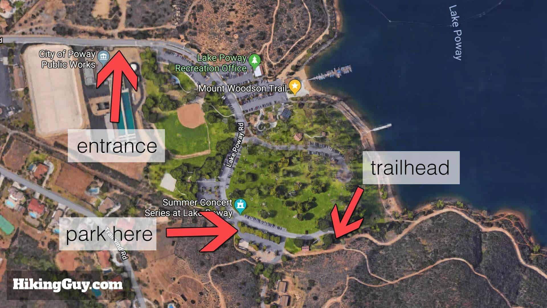 map layout of potato chip rock trailhead
What to Expect Along the Lake Poway Trail
The Lake Poway Trail offers a diverse landscape, from the tranquil lake views to the rugged terrain leading to the summit. Hikers can expect well-maintained paths, occasional shade, and several junctions that require attention to stay on the correct route. According to research from Arizona State University’s School of Earth and Space Exploration, the unique geological formations along the trail are a result of millions of years of erosion and tectonic activity.
4. Tips for a Successful Hike
Proper preparation is crucial for a safe and enjoyable hike to Potato Chip Rock. Consider these essential tips to ensure a successful trip.
What to Bring
- Water: Carry at least 1 to 3 liters of water, depending on the weather and your personal needs.
- Snacks: Pack high-energy snacks like trail mix, energy bars, fruits, and nuts.
- Sun Protection: Wear sunscreen, a hat, and sunglasses to protect yourself from the sun.
- Appropriate Clothing: Dress in layers to adjust to changing temperatures.
- Hiking Shoes: Wear sturdy hiking shoes with good traction.
- Map and Compass/GPS: Bring a map and compass or GPS device to stay on the trail.
- First Aid Kit: Carry a basic first aid kit for minor injuries.
- Camera: Capture the stunning views and memorable moments.
When to Go
- Best Time of Year: Spring and fall offer the most pleasant weather for hiking.
- Time of Day: Start early in the morning to avoid the midday heat and crowds.
- Weather Conditions: Check the weather forecast before you go and avoid hiking during extreme heat or storms.
Safety Considerations
- Stay on the Trail: Stick to marked trails to avoid getting lost and protect the environment.
- Hike with a Buddy: Hiking with a friend is safer and more enjoyable.
- Inform Someone of Your Plans: Let someone know your hiking plans and estimated return time.
- Be Aware of Wildlife: Be cautious of wildlife and maintain a safe distance.
- Conserve Energy: Pace yourself and take breaks when needed.
5. Safety Measures and Potential Hazards
While the Potato Chip Rock hike is generally safe, it’s important to be aware of potential hazards and take necessary precautions.
Common Injuries
- Heat Exhaustion: Dehydration and overheating can lead to heat exhaustion.
- Sprains and Strains: Uneven terrain can cause sprains and strains.
- Cuts and Scrapes: Rocky sections may result in minor cuts and scrapes.
- Falls: Slippery or steep areas can increase the risk of falls.
Environmental Hazards
- Extreme Heat: The area can experience high temperatures, especially during summer.
- Dehydration: Lack of water can lead to dehydration.
- Wildlife: Encounters with snakes, insects, and other wildlife are possible.
- Sun Exposure: Prolonged sun exposure can cause sunburn and heat-related illnesses.
Safety Tips
- Hydrate Regularly: Drink plenty of water throughout the hike.
- Wear Appropriate Gear: Use proper hiking shoes and clothing.
- Take Breaks: Rest in shaded areas to avoid overheating.
- Watch Your Step: Pay attention to the trail and avoid risky maneuvers.
- Be Prepared for Emergencies: Carry a first aid kit and know how to use it.
Emergency Contacts
- Emergency Services: Dial 911 for immediate assistance.
- Lake Poway Park Rangers: Contact park rangers for assistance within the park.
- Local Hospitals: Know the location of the nearest hospitals for medical emergencies.
6. Enhancing Your Hiking Experience
Beyond the physical preparation and safety measures, there are several ways to enhance your hiking experience and make it even more enjoyable.
Photography Tips
- Best Lighting: Early morning and late afternoon provide the best lighting for photos.
- Composition: Use natural elements to frame your shots and create visual interest.
- Angles: Experiment with different angles to capture unique perspectives.
- Equipment: Bring a camera or smartphone with good photo capabilities.
Exploring the Flora and Fauna
- Local Plants: The area is home to various native plants, including wildflowers, shrubs, and trees.
- Wildlife: Keep an eye out for birds, reptiles, and small mammals.
- Respect Nature: Avoid disturbing plants and wildlife, and leave no trace behind.
Understanding the Geology
- Rock Formations: The unique rock formations, including Potato Chip Rock, are a result of geological processes.
- Spheroidal Weathering: The boulder fields are formed by spheroidal weathering, where joints in the rocks erode over time.
- Local Geology: Research the local geology to gain a deeper appreciation for the landscape. According to research from Arizona State University’s School of Earth and Space Exploration, in July 2025, the region’s diverse geology provides valuable insights into Earth’s history.
Utilizing rockscapes.net for More Information
Rockscapes.net is your go-to resource for detailed information about rock formations, hiking trails, and geological wonders. Explore our site for:
- Detailed Trail Guides: Comprehensive guides for various hiking trails.
- Geological Insights: Articles and resources on the geology of different regions.
- Photography Tips: Tips and tricks for capturing stunning landscape photos.
- Community Forum: Connect with other hikers and share your experiences.
7. The Impact of Weathering on Rock Formations
Weathering plays a crucial role in shaping the unique rock formations seen on the Potato Chip Rock hike.
Types of Weathering
- Physical Weathering: This involves the mechanical breakdown of rocks into smaller pieces without changing their chemical composition. Examples include freeze-thaw cycles and abrasion.
- Chemical Weathering: This involves the chemical alteration of rocks through processes like oxidation, hydrolysis, and carbonation.
- Biological Weathering: This involves the breakdown of rocks by living organisms, such as plant roots and lichens.
Spheroidal Weathering Explained
Spheroidal weathering is a specific type of weathering that results in the rounded, boulder-like formations seen on the Mt. Woodson Trail. This process occurs when water penetrates joints and fractures in the rock, causing the edges and corners to erode more rapidly than the flat surfaces.
Process of Spheroidal Weathering
- Fracturing: Rocks develop cracks and joints due to stress and tectonic activity.
- Water Penetration: Water seeps into these cracks, often containing dissolved minerals and acids.
- Chemical Reactions: Chemical reactions occur between the water and the rock, weakening the rock material.
- Erosion: The edges and corners of the rock erode more quickly, resulting in a rounded shape.
- Exposure: Over time, the weathered rock is exposed as surrounding material is removed by erosion.
Examples of Weathering on the Potato Chip Rock Hike
- Potato Chip Rock: The thin, fragile appearance of Potato Chip Rock is a result of continuous weathering and erosion.
- Boulder Fields: The rounded boulders along the trail are classic examples of spheroidal weathering.
- Eroded Surfaces: Smooth, weathered surfaces on rocks indicate long-term exposure to the elements.
8. Alternative Hikes in the Area
If you’re looking for other hiking options in the San Diego area, there are several alternatives that offer diverse landscapes and challenges.
Cowles Mountain
Cowles Mountain is the highest point in the city of San Diego and offers panoramic views of the surrounding area.
- Distance: Approximately 3 miles round trip
- Difficulty: Moderate
- Highlights: 360-degree views, well-maintained trail
Torrey Pines State Natural Reserve
Torrey Pines State Natural Reserve features dramatic cliffs, ocean views, and unique plant life.
- Distance: Varies depending on the trail, but typically 2-5 miles
- Difficulty: Easy to Moderate
- Highlights: Coastal scenery, diverse hiking trails
Mission Trails Regional Park
Mission Trails Regional Park offers a variety of hiking trails with diverse terrain and scenic views.
- Distance: Varies depending on the trail
- Difficulty: Easy to Strenuous
- Highlights: Diverse trails, natural landscapes
El Cajon Mountain (El Capitan)
El Cajon Mountain, also known as El Capitan, is a challenging hike with significant elevation gain and rugged terrain.
- Distance: Approximately 11 miles round trip
- Difficulty: Strenuous
- Highlights: Challenging hike, panoramic views
9. Frequently Asked Questions (FAQs)
Here are some frequently asked questions about the Potato Chip Rock hike to help you plan your trip effectively.
1. How long does it take to hike to Potato Chip Rock?
The hike to Potato Chip Rock typically takes 3 to 5 hours, depending on your fitness level and the route you choose.
2. Is the Potato Chip Rock hike suitable for beginners?
The Lake Poway route is moderately challenging and may be difficult for beginners. The shorter, steeper route from Highway 67 is even more strenuous.
3. Are there restrooms along the trail?
Restrooms are available at the Lake Poway park and at a junction along the Mt. Woodson Trail. There are no restrooms on the Mt. Woodson Trail from Highway 67 or the Fry-Koegel Trail.
4. Is there an entrance fee for Lake Poway Park?
Yes, there is a non-resident fee on weekends and holidays. Weekdays are usually free. Poway residents with ID can enter for free.
5. Can I bring my dog on the hike?
Yes, dogs are allowed on the trail but must be kept on a leash.
6. Is there shade on the trail?
There is very little shade on the trail, so it’s important to wear sun protection and bring plenty of water.
7. What is the best time of year to hike to Potato Chip Rock?
Spring and fall offer the most pleasant weather for hiking.
8. How crowded does the trail get?
The trail can get very crowded, especially on weekends and holidays. It’s best to start early in the morning to avoid the crowds.
9. Is Potato Chip Rock safe to stand on?
Potato Chip Rock is generally safe, but it’s important to exercise caution and avoid risky poses.
10. What should I do in case of an emergency on the trail?
Dial 911 for immediate assistance. Be prepared with a first aid kit and inform someone of your hiking plans before you go.
10. Rockscapes.net: Your Ultimate Resource for Rock Landscapes
At rockscapes.net, we are passionate about rocks and landscapes. Our website provides a wealth of information, inspiration, and resources for outdoor enthusiasts, nature lovers, and anyone interested in the beauty and geology of rock formations.
Explore Our Website
- Hiking Guides: Discover detailed guides for various hiking trails around the world.
- Geological Information: Learn about the geological processes that shape our landscapes.
- Photography Tips: Get tips and tricks for capturing stunning landscape photos.
- Community Forum: Connect with other rock and landscape enthusiasts.
- Rock and Mineral Identification: Identify different types of rocks and minerals.
- Landscape Design Ideas: Find inspiration for incorporating rocks into your landscape design.
Our Mission
Our mission is to inspire a deeper appreciation for the natural world and to provide the resources and knowledge needed to explore and protect our planet’s unique landscapes. We believe that by understanding and valuing our natural environment, we can make informed decisions and create a more sustainable future.
Connect With Us
- Visit our website: rockscapes.net
- Follow us on social media: Stay updated with our latest articles, photos, and news.
- Join our community forum: Share your experiences and connect with other enthusiasts.
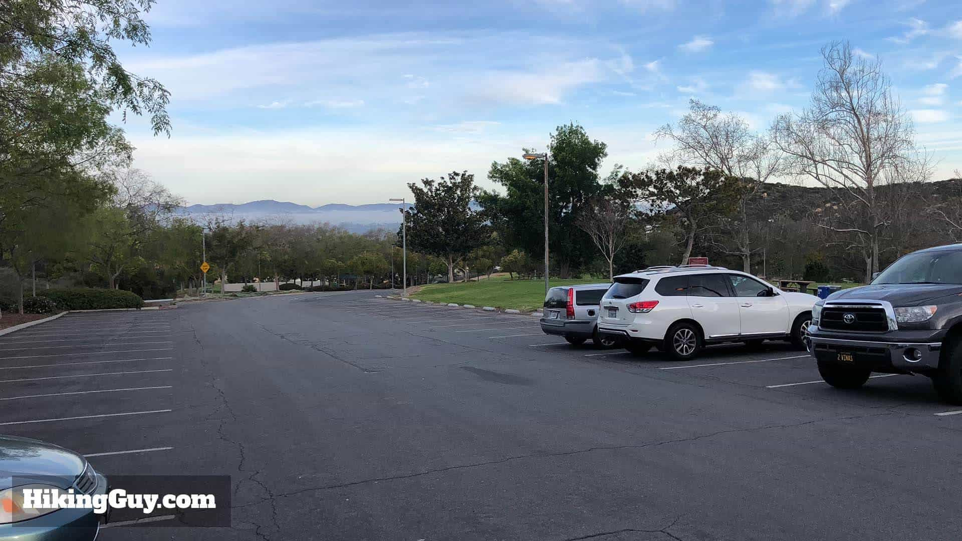 parking lot in poway
The Potato Chip Rock hike offers a unique and rewarding experience for outdoor enthusiasts. By understanding the distance, preparing adequately, and taking necessary safety precautions, you can enjoy a memorable adventure in this stunning landscape. Visit rockscapes.net for more inspiration and resources to fuel your passion for rock formations and geological wonders.
Ready to explore the beauty of rock landscapes? Contact us today for expert advice and personalized recommendations:
rockscapes.net
Address: 1151 S Forest Ave, Tempe, AZ 85281, United States
Phone: +1 (480) 965-9011
Website: rockscapes.net
Discover the wonders of rock landscapes with us!