Yosemite National Park, a jewel of the Sierra Nevada, is renowned for its iconic vistas and towering granite monoliths. While names like El Capitan and Half Dome resonate globally, countless lesser-known spots hold their own captivating stories. Among these, Moonlight Rock stands as a testament to Yosemite’s rich history and the evolving paths that have led visitors to its most breathtaking viewpoints. This exploration delves into the mystery of Moonlight Rock, tracing its location and uncovering its connection to Yosemite’s early trails and photographic legacy.
Our journey begins with a quest to locate this elusive landmark, a task made all the more intriguing by its proximity to the well-trodden paths of Yosemite Valley. Like many who venture into Yosemite’s embrace, the allure of the park’s historical trails and abandoned routes is undeniable. The desire to walk in the footsteps of early explorers and photographers fuels a deeper appreciation for this natural wonder. Recently, an exploration with grandkids, while geared towards family-friendly destinations like Oh My Gosh Point and Mirror Lake, couldn’t resist a detour into Yosemite’s past.
The discovery of “The Inventor and the Tycoon,” a book detailing the lives of Leland Stanford and Eadweard Muybridge, provided a crucial historical thread. Muybridge, the pioneering photographer known for his motion studies, was also a figure shrouded in controversy. His life, marked by both brilliance and darkness, included a dramatic episode of murder and an insanity plea partly supported by photographs taken on the cliffs of Yosemite. Beyond the drama, Muybridge was a visionary who, in 1872, carried a large plate camera into Yosemite Valley and captured its majesty for the world to see. One photograph, taken from a place called Moonlight Rock, became particularly famous.
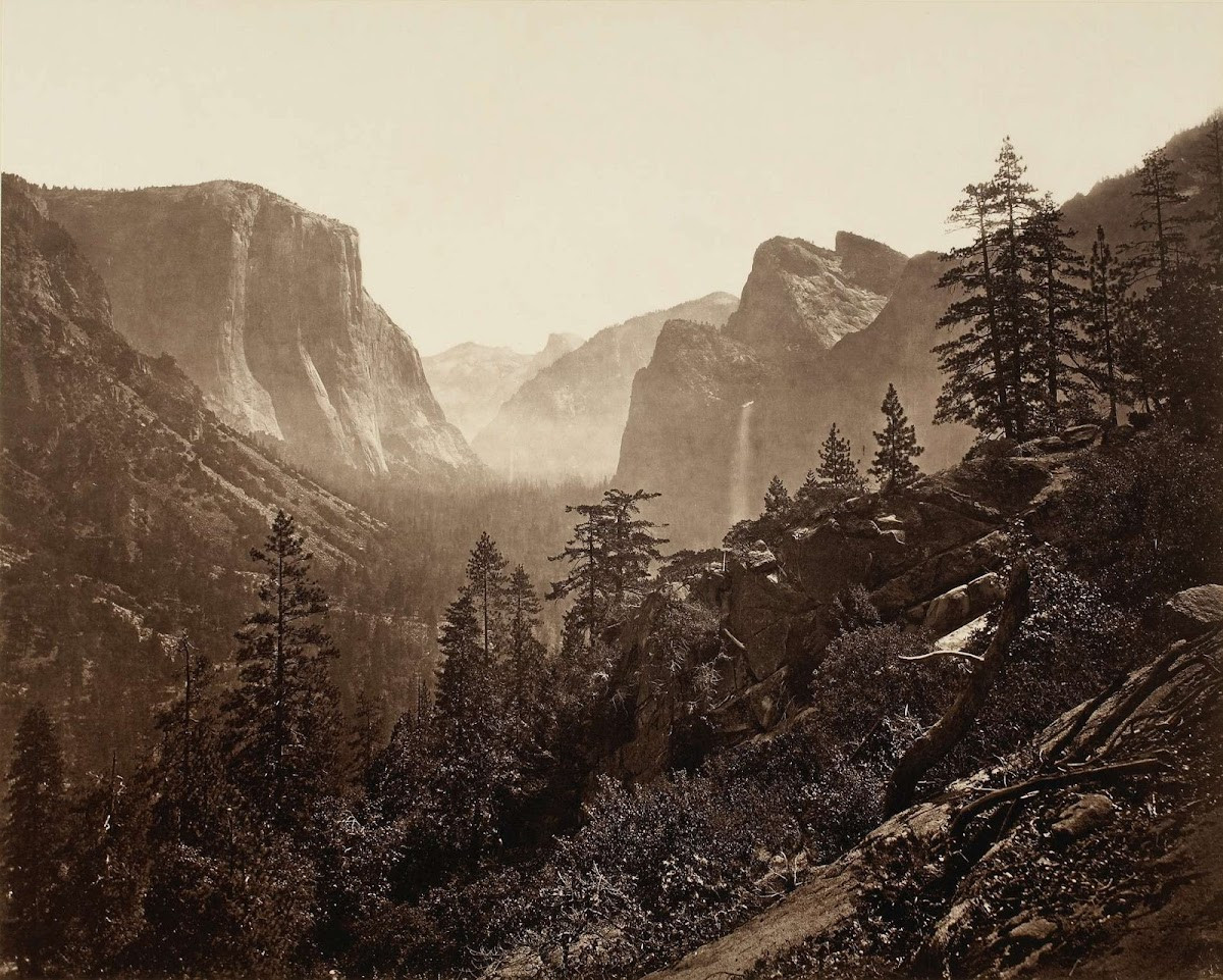 Eadweard Muybridge's 1872 photograph from Moonlight Rock, Yosemite Valley. The image captures the expansive view, although early photographic limitations obscure Sentinel Rock due to blue-sensitive emulsions and atmospheric haze.
Examining Muybridge’s 1872 photograph, the view immediately sparks recognition. The composition hints at a location near Inspiration Point, a famous vista overlooking Yosemite Valley. Furthermore, the timing of the photograph places Moonlight Rock in a specific historical context. In 1872, roads were yet to penetrate Yosemite Valley. The Old Big Oak Flat Road and the Wawona Road were future constructions. The primary access was the Mariposa Trail, a mule trail descending into the valley. This temporal clue strongly suggests that Moonlight Rock must lie along or near the path of the old Mariposa Trail.
The logistics of large plate photography in the 1870s further emphasize the significance of trail access. These cameras were cumbersome, requiring photographers to prepare their photographic emulsions on-site in portable dark tents just before exposure. Mules were essential for transporting this equipment. Therefore, Moonlight Rock’s accessibility via the Mariposa Trail becomes not just plausible, but almost a necessity for Muybridge’s photographic endeavor.
The naming conventions of Yosemite’s viewpoints also offer insights. Early tour guides, often muleteers, played a crucial role in popularizing and naming scenic spots along their routes. To impress tourists, they christened numerous locations, ensuring a sense of discovery and wonder. This practice explains why today’s Inspiration Point is situated where it is. The original Inspiration Point was located along the Mariposa mule trail. When the Wawona Road was constructed, bypassing the original viewpoint, a “new” Inspiration Point was designated where the road intersected the old trail. This historical renaming suggests that Moonlight Rock, being near the old Mariposa Trail, is likely in the vicinity of the original Inspiration Point.
Historical maps provide further clues to pinpoint Moonlight Rock’s location. Early maps consistently depict the Mariposa Trail descending the ridge to the “new” Inspiration Point and then continuing towards the Merced River near the Pohono Bridge. The Old Wawona Road, in contrast, followed a different route, crossing the Mariposa Trail below Inspiration Point. These maps highlight the Mariposa Trail’s importance as the primary access route before road construction altered Yosemite’s landscape.
 An 1893 USGS map, based on the 1883 Wheeler map, highlighting roads in red. This map clearly shows the Mariposa Trail connecting to the road at Inspiration Point and continuing down into Yosemite Valley.
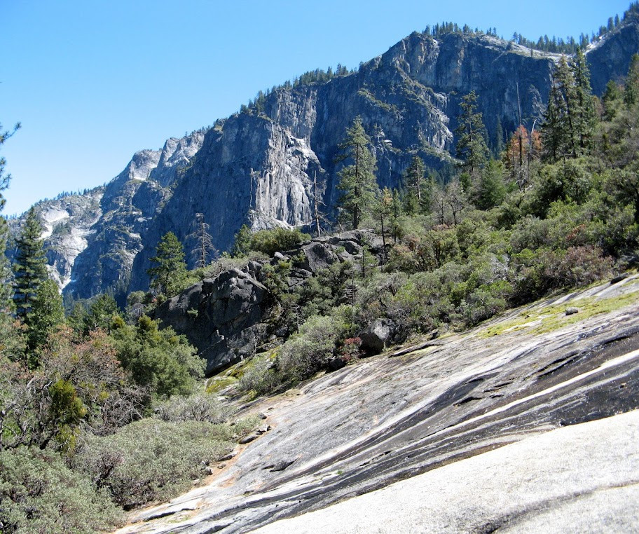
By comparing these historical maps with the present-day landscape, and armed with Muybridge’s photograph, the search for Moonlight Rock becomes increasingly focused. A visit to Discovery View (Tunnel View parking lot) proved to be the pivotal moment. Standing at the trailhead at the east end of the parking area and aligning landmarks like Lower Cathedral Rock, Sentinel Rock, and Half Dome with the perspective in Muybridge’s photo revealed a startling realization: Moonlight Rock was not some distant, hidden promontory. It was right there, practically underfoot. In fact, the modern parking lot and trailhead for Discovery View are built at the very base of Moonlight Rock and directly intersect the original Mariposa Trail.
 Standing at the trailhead of Discovery View, the location of Moonlight Rock becomes apparent, aligning perfectly with the historical Mariposa Trail.
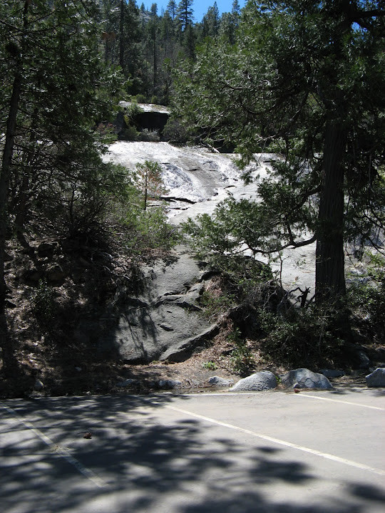
Just a short walk up the trail confirms the discovery. The distinctive escarpment visible in Muybridge’s 1872 photograph becomes unmistakable. Stepping onto the wet rock reveals the same panoramic vista, albeit partially obscured by trees that have grown over time. The view from the parking lot itself is virtually identical, underscoring how easily this historical landmark has been overlooked in plain sight. What took Muybridge half a day to capture in 1872 can now be photographed in mere seconds with modern technology.
 The panorama from Moonlight Rock today, closely mirroring Muybridge's 1872 photograph, showcasing the enduring vista despite the passage of time and some tree growth.
The name “Moonlight Rock” itself likely derives from the way the rock surface glistens in the sunlight when moist, a frequent condition, especially during spring. This reflective quality, perhaps particularly striking under moonlight, could have inspired the evocative name bestowed upon this viewpoint by early Yosemite travelers.
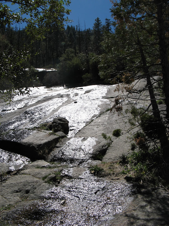 Moonlight Rock glistening with moisture, possibly the origin of its name, highlighting the rock's reflective surface in Yosemite's environment.
The rediscovery of Moonlight Rock offers a tangible connection to Yosemite’s past. It reminds us that even within the most visited and photographed landscapes, historical layers remain to be uncovered. While the planned hike continued towards Inspiration Point and Bridalveil Fall, the exploration sparked a new question: what remains of the Mariposa Trail extending from Discovery View and Moonlight Rock down to the Pohono Bridge? This untrodden section of abandoned trail beckons, promising further adventures into Yosemite’s rich tapestry of natural beauty and historical intrigue, waiting to be explored another day.