Nestled in the picturesque landscapes of Crestline, CA, the Heart Rock Trail, also known as the path to Seely Creek Falls, offers a unique and captivating hiking experience. While the 25-foot waterfall at the trail’s end is undeniably beautiful, the true marvel lies just beside it: a naturally carved heart rock formation. This stunning feature, seemingly small in photos yet large enough to cradle two adults within its halves, makes this trail a must-visit destination. A hidden gem within the San Bernardino Mountains, Heart Rock Trail was a surprising find even for seasoned locals like myself, having lived in Southern California for years. Just a short drive from the Inland Empire (about 30 minutes) and within easy reach of Los Angeles (approximately 1.5 hours), this accessible trail is perfect for a family outing. Read on to uncover all you need to know for your Heart Rock adventure.
 Heart Rock Falls showcases its unique heart-shaped rock formation
Trail Essentials for Your Heart Rock Hike
Before you embark on your heart rock trail adventure, here are some key details to ensure a smooth and enjoyable experience:
- Distance: Approximately 2 miles round trip, making it an ideal short hike for various skill levels.
- Road Access: Be aware that the road leading to the trailhead is a single-lane road. Drive slowly and cautiously, especially around bends.
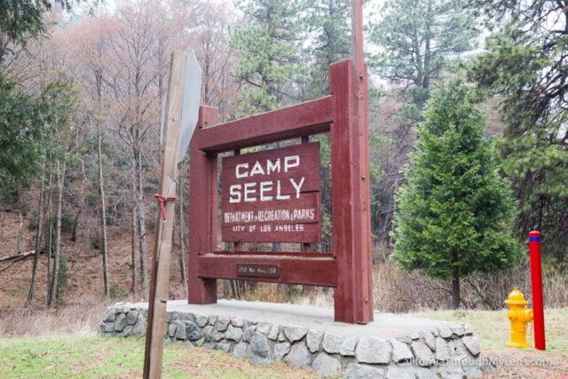
- Trailhead Location: 250 CA-138, Crestline, CA 92325. Easily searchable for GPS navigation.
- Parking Permit: An Adventure Pass is required for parking at the trailhead. You can purchase one at various locations, including sporting goods stores like REI.
Navigating to the Heart Rock Trailhead
Finding the trailhead for the Heart Rock Trail can feel like uncovering a secret, as signage is minimal. However, with clear directions, your journey will be straightforward.
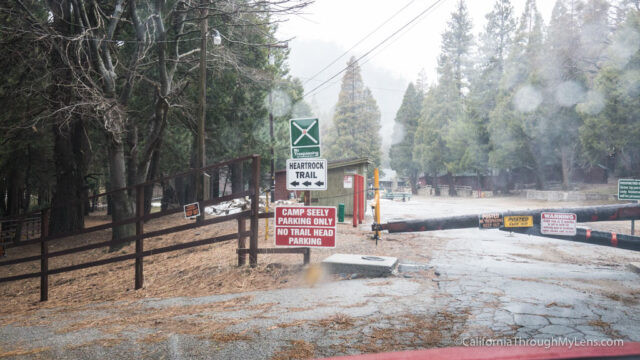
 Road leading to Heart Rock Trail parking area in Crestline
From Highway 210, take Waterman Ave north into the mountains for about 13 miles. Then, merge onto Highway 138 towards Crestline. Continue until you spot the sign for Camp Seeley. Turn onto this road and head left, away from the main parking area, onto the one-lane road. Follow this road to its end – this is where the trailhead is located.
 Parking area at the start of Heart Rock Trail near Camp Seeley
Park your vehicle, ensuring your Adventure Pass is displayed. Walk down the small hill towards the swimming pool area. You’ll notice a well-trodden path – this marks the beginning of the Heart Rock Trail. If you prefer using GPS, simply search for “Heart Rock Falls” in Google Maps or your preferred navigation app, which will guide you to the vicinity of the trailhead.
Hiking the Scenic Heart Rock Trail
The Heart Rock Trail itself is a delight, characterized by its lush greenery and shaded path, thanks to the canopy of trees and foliage. The trail follows Seely Creek, offering the soothing sounds of nature as your hiking soundtrack.
 Shaded hiking path along Heart Rock Trail with lush trees
During your walk, you might encounter natural trail obstacles such as fallen trees, especially after storms, adding a touch of adventure to your hike.
 Fallen tree across the Heart Rock Trail after a storm
Keep an eye out for a large, distinctive tree that seems straight out of a fantasy movie – this landmark signifies a trail split. It’s crucial to spot this split to stay on the correct path to Heart Rock Waterfall.
 Trail split marked by a large tree on the path to Heart Rock
In the past, a painted heart on a rock served as a marker for the turn-off to the falls. While such markings are not officially endorsed, they have historically helped hikers identify the correct direction.
 Rock with a painted heart symbol marking the turn towards Heart Rock Waterfall
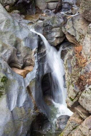
Witnessing the Natural Wonder of Heart Rock Waterfall
Upon reaching the trail split, take the path to the right. This will lead you directly to the area above Heart Rock Waterfall, offering your first breathtaking views of the heart-shaped rock and the cascading water.
 Overhead view of Heart Rock Waterfall and heart-shaped rock formation
From this vantage point, you can venture onto a natural ledge for an even closer look at the heart rock. Exercise extreme caution here, as there is a significant drop of approximately 40 feet, and the ledge can be slippery.
 Vertical view of Heart Rock Waterfall showing the scale of the heart rock
Explore the surrounding rocks to find the perfect angle to capture both the heart rock and the waterfall in one frame. Keep in mind that the waterfall’s flow is seasonal, often drying up during the summer months. For the most impressive waterfall experience, visit during or after a year with substantial rainfall.
Heart Rock Falls showcases its unique heart-shaped rock formation
For a different perspective, you can also hike down to the base of the 25-foot waterfall. While the heart rock is not visible from this angle, you can appreciate the beauty and power of Seely Creek Falls up close and even wade in the refreshing water.
 Base of Heart Rock Waterfall with wading hikers exploring the area
To truly grasp the size of the heart rock, take a look at the image below, which includes a person for scale. You might be surprised at just how large this natural heart is compared to online images.
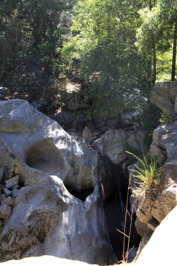 Person standing above Heart Rock Waterfall to show the size of the heart rock
Explore More:
For a visual journey of the Heart Rock Trail, check out this video: [Insert Video Link Here – You can link to a relevant YouTube video about Heart Rock Trail if available or embed the original one if suitable for English-speaking audience].
In conclusion, the Heart Rock Trail is a short yet incredibly rewarding hike that offers a unique natural attraction. Its accessibility and stunning heart rock formation make it a fantastic destination for individuals and families alike. Plan your visit to this Southern California treasure and experience the magic of Heart Rock for yourself. Discover more captivating rock formations and trails at rockscapes.net.